Huntersville elevation
Huntersville (North Carolina, Mecklenburg County), United States elevation is 248 meters and Huntersville elevation in feet is 814 ft above sea level [src 1]. Huntersville is a populated place (feature code) with elevation that is 31 meters (102 ft) smaller than average city elevation in United States.
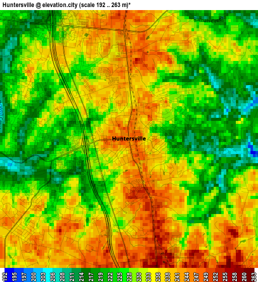
Below is the Elevation map of Huntersville, which displays elevation range with different colors. Scale of the first map is from 192 to 263 m (630 to 863 ft) with average elevation of 231.7 meters (=760 ft) [note 1]
These maps also provides idea of topography and contour of this city, they are displayed at different zoom levels. More info about maps, scale and edge coordinates you can find below images.
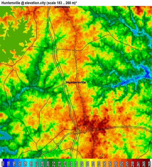
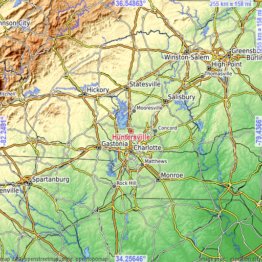
| \ | Map #1 | Map #2 | Topo.Map |
| Scale [m] | 192..263 m | 183..268 m | × |
| Scale [ft] | 630..863 ft | 600..879 ft | × |
| Average | 231.7 m = 760 ft | 229.8 m = 754 ft | × |
| Width | 7.96 km = 4.9 mi | 15.93 km = 9.9 mi | 254.9 km = 158.4 mi |
| Height | 7.96 km = 4.9 mi | 15.93 km = 9.9 mi | 254.9 km = 158.4 mi |
| ↑Max Latitude | 35.446498° | 35.482291° | 36.54863° |
| Latitude at center | 35.41069° | 35.41069° | 35.41069° |
| ↓Min Latitude | 35.374866° | 35.339026° | 34.25646° |
| ← Min Longitude | -80.886795° | -80.930741° | -82.2491° |
| Longitude center | -80.84285° | -80.84285° | -80.84285° |
| →Max Longitude | -80.798905° | -80.754959° | -79.4366° |
Nearby cities:
Cities around Huntersville sort by population:
• Charlotte elevation 272 m
20.4 km,  180°
180°
• Kannapolis 247 m
21.8 km,  66°
66°
• Mooresville 276 m
19.6 km,  8°
8°
• Cornelius 243 m
8.6 km,  349°
349°
• Harrisburg 197 m
19.3 km,  119°
119°
• Mount Holly 187 m
20.1 km,  231°
231°
• Davidson 242 m
10.2 km,  1°
1°
• Lake Norman of Catawba 247 m
22.2 km,  331°
331°
• Westport 245 m
15.9 km,  309°
309°
• Lowesville 240 m
15.3 km,  272°
272°
• Enochville 264 m
20.6 km,  50°
50°
• Denver 276 m
21.6 km, 308°
Multilingual:
 En español:
Huntersville elevación 248 m.
 En France:
Huntersville élévation 248 m.
 Auf Deutsch:
Huntersville höhe über dem Meeresspiegel ist 248 m.

Sources and notes:
- [note 1] Map square and city borders are not equal. Map elevation data is calculated only from area inside that square.
- [src 1] Elevation data from geonames database provided with same terms of usage.
- [src 2] The elevation map of Huntersville is generated using elevation data from NASA's 3 arcsec (90m) resolution SRTM data.
- [src 3] Base (background) map © OpenStreetMap contributors tiles are generated by Geofabrik and OpenTopoMap.
Copyright & License:
This Huntersville Elevation Map is licensed under CC BY-SA. You may reuse any part from this page, if you give a proper credit by linking to this URL:
 More info on terms of use page.