Elizabethtown elevation
Elizabethtown (North Carolina, Bladen County), United States elevation is 36 meters and Elizabethtown elevation in feet is 118 ft above sea level [src 1]. Elizabethtown is a seat of a second-order administrative division (feature code) with elevation that is 243 meters (797 ft) smaller than average city elevation in United States.
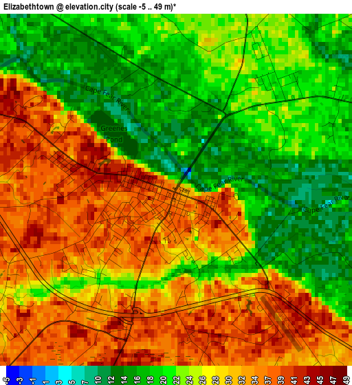
Below is the Elevation map of Elizabethtown, which displays elevation range with different colors. Scale of the first map is from -5 to 49 m (-16 to 161 ft) with average elevation of 26.6 meters (=87 ft) [note 1]
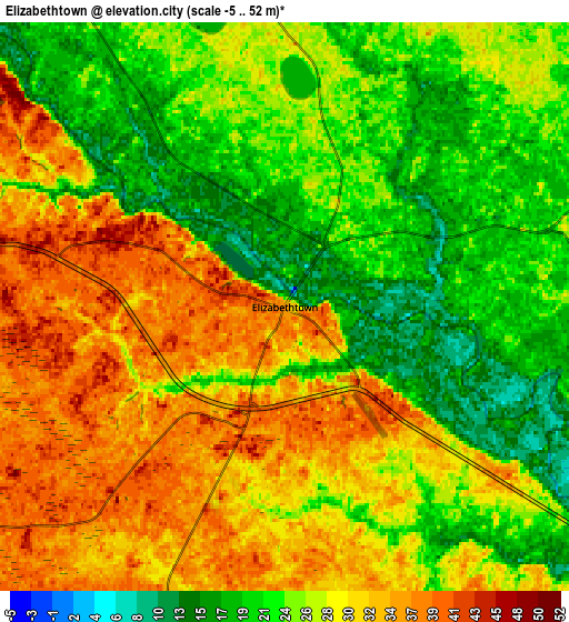
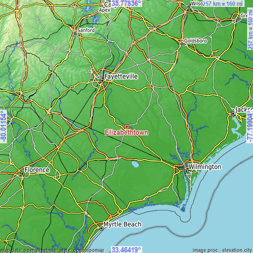
These maps also provides idea of topography and contour of this city, they are displayed at different zoom levels. More info about maps, scale and edge coordinates you can find below images.
| \ | Map #1 | Map #2 | Topo.Map |
| Scale [m] | -5..49 m | -5..52 m | × |
| Scale [ft] | -16..161 ft | -16..171 ft | × |
| Average | 26.6 m = 87 ft | 27.1 m = 89 ft | × |
| Width | 8.04 km = 5 mi | 16.08 km = 10 mi | 257.3 km = 159.9 mi |
| Height | 8.04 km = 5 mi | 16.08 km = 10 mi | 257.3 km = 159.9 mi |
| ↑Max Latitude | 34.665492° | 34.701629° | 35.77836° |
| Latitude at center | 34.62934° | 34.62934° | 34.62934° |
| ↓Min Latitude | 34.593172° | 34.556988° | 33.46419° |
| ← Min Longitude | -78.649235° | -78.693181° | -80.01154° |
| Longitude center | -78.60529° | -78.60529° | -78.60529° |
| →Max Longitude | -78.561345° | -78.517399° | -77.19904° |
Nearby cities:
Cities around Elizabethtown sort by population:
• Lumberton elevation 29 m
37.1 km,  268°
268°
• Clinton 47 m
48.4 km,  32°
32°
• Whiteville 25 m
33.5 km,  195°
195°
• Fairmont 33 m
48.9 km,  252°
252°
• Saint Pauls 53 m
38.8 km,  300°
300°
• Chadbourn 28 m
39.7 km,  210°
210°
• Bladenboro 34 m
19.5 km,  238°
238°
• Lake Waccamaw 18 m
35.8 km,  164°
164°
• Roseboro 43 m
37 km,  13°
13°
• Vander 39 m
48 km,  338°
338°
• Brunswick 18 m
39.1 km,  192°
192°
• Stedman 39 m
43.5 km,  349°
349°
Multilingual:
 En español:
Elizabethtown elevación 36 m.
 En France:
Elizabethtown élévation 36 m.
 Auf Deutsch:
Elizabethtown höhe über dem Meeresspiegel ist 36 m.

Sources and notes:
- [note 1] Map square and city borders are not equal. Map elevation data is calculated only from area inside that square.
- [src 1] Elevation data from geonames database provided with same terms of usage.
- [src 2] The elevation map of Elizabethtown is generated using elevation data from NASA's 3 arcsec (90m) resolution SRTM data.
- [src 3] Base (background) map © OpenStreetMap contributors tiles are generated by Geofabrik and OpenTopoMap.
Copyright & License:
This Elizabethtown Elevation Map is licensed under CC BY-SA. You may reuse any part from this page, if you give a proper credit by linking to this URL:
 More info on terms of use page.