Cramerton elevation
Cramerton (North Carolina, Gaston County), United States elevation is 190 meters and Cramerton elevation in feet is 623 ft above sea level [src 1]. Cramerton is a populated place (feature code) with elevation that is 89 meters (292 ft) smaller than average city elevation in United States.
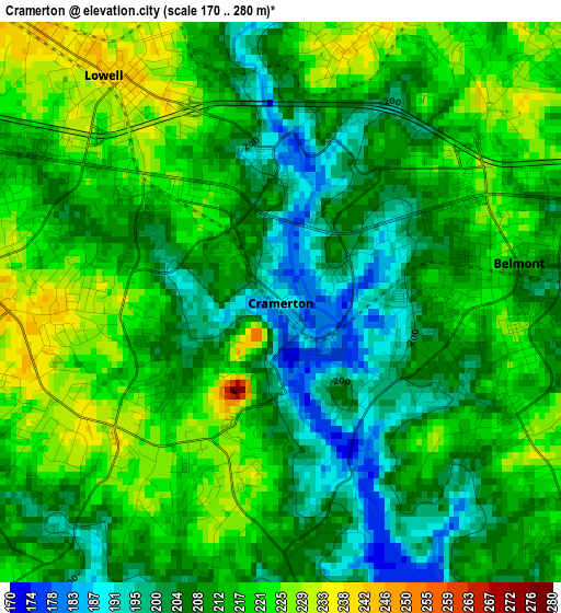
Below is the Elevation map of Cramerton, which displays elevation range with different colors. Scale of the first map is from 170 to 280 m (558 to 919 ft) with average elevation of 212.3 meters (=697 ft) [note 1]
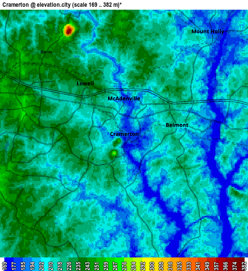
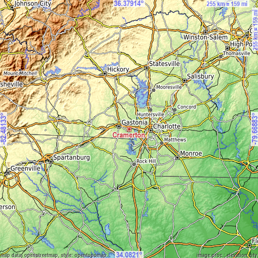
These maps also provides idea of topography and contour of this city, they are displayed at different zoom levels. More info about maps, scale and edge coordinates you can find below images.
| \ | Map #1 | Map #2 | Topo.Map |
| Scale [m] | 170..280 m | 169..382 m | × |
| Scale [ft] | 558..919 ft | 554..1253 ft | × |
| Average | 212.3 m = 697 ft | 213.8 m = 701 ft | × |
| Width | 7.98 km = 5 mi | 15.96 km = 9.9 mi | 255.4 km = 158.7 mi |
| Height | 7.98 km = 5 mi | 15.96 km = 9.9 mi | 255.4 km = 158.7 mi |
| ↑Max Latitude | 35.274635° | 35.310503° | 36.37914° |
| Latitude at center | 35.23875° | 35.23875° | 35.23875° |
| ↓Min Latitude | 35.20285° | 35.166933° | 34.0821° |
| ← Min Longitude | -81.119025° | -81.162971° | -82.48133° |
| Longitude center | -81.07508° | -81.07508° | -81.07508° |
| →Max Longitude | -81.031135° | -80.987189° | -79.66883° |
Nearby cities:
Cities around Cramerton sort by population:
• Gastonia elevation 249 m
10.5 km,  284°
284°
• Mount Holly 187 m
8.5 km,  39°
39°
• Belmont 211 m
3.5 km,  82°
82°
• Lake Wylie 181 m
14.8 km,  168°
168°
• Clover 248 m
19.8 km,  224°
224°
• Bessemer City 278 m
19.6 km,  285°
285°
• South Gastonia 233 m
12.1 km,  259°
259°
• Dallas 245 m
12.6 km,  313°
313°
• Stanley 260 m
13.5 km,  351°
351°
• Lowell 242 m
4.1 km,  322°
322°
• Ranlo 243 m
7.3 km, 316°
• Lowesville 240 m
20.7 km,  16°
16°
Multilingual:
 En español:
Cramerton elevación 190 m.
 En France:
Cramerton élévation 190 m.
 Auf Deutsch:
Cramerton höhe über dem Meeresspiegel ist 190 m.

Sources and notes:
- [note 1] Map square and city borders are not equal. Map elevation data is calculated only from area inside that square.
- [src 1] Elevation data from geonames database provided with same terms of usage.
- [src 2] The elevation map of Cramerton is generated using elevation data from NASA's 3 arcsec (90m) resolution SRTM data.
- [src 3] Base (background) map © OpenStreetMap contributors tiles are generated by Geofabrik and OpenTopoMap.
Copyright & License:
This Cramerton Elevation Map is licensed under CC BY-SA. You may reuse any part from this page, if you give a proper credit by linking to this URL:
 More info on terms of use page.