Burlington elevation
Burlington (North Carolina, Alamance County), United States elevation is 197 meters and Burlington elevation in feet is 646 ft above sea level [src 1]. Burlington is a populated place (feature code) with elevation that is 82 meters (269 ft) smaller than average city elevation in United States.
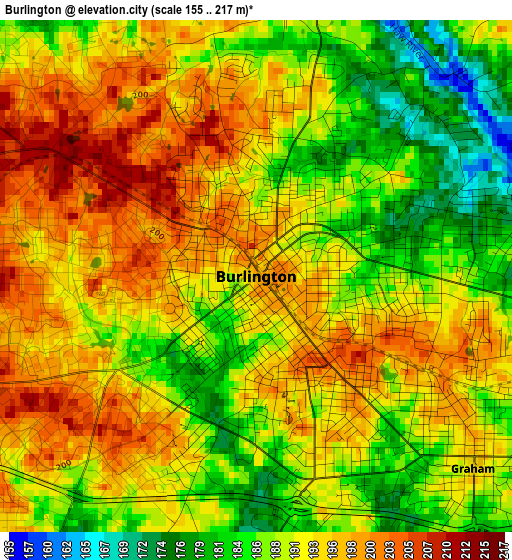
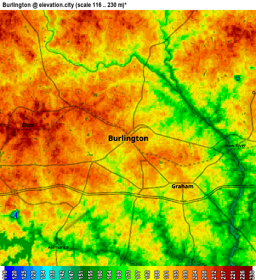
Below is the Elevation map of Burlington, which displays elevation range with different colors. Scale of the first map is from 155 to 217 m (509 to 712 ft) with average elevation of 191.5 meters (=628 ft) [note 1]
These maps also provides idea of topography and contour of this city, they are displayed at different zoom levels. More info about maps, scale and edge coordinates you can find below images.
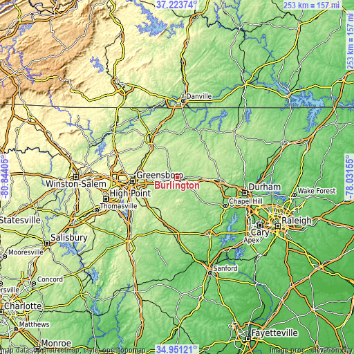
| \ | Map #1 | Map #2 | Topo.Map |
| Scale [m] | 155..217 m | 116..230 m | × |
| Scale [ft] | 509..712 ft | 381..755 ft | × |
| Average | 191.5 m = 628 ft | 187.8 m = 616 ft | × |
| Width | 7.9 km = 4.9 mi | 15.79 km = 9.8 mi | 252.7 km = 157 mi |
| Height | 7.9 km = 4.9 mi | 15.79 km = 9.8 mi | 252.7 km = 157 mi |
| ↑Max Latitude | 36.131191° | 36.166677° | 37.22374° |
| Latitude at center | 36.09569° | 36.09569° | 36.09569° |
| ↓Min Latitude | 36.060173° | 36.024639° | 34.95121° |
| ← Min Longitude | -79.481745° | -79.525691° | -80.84405° |
| Longitude center | -79.4378° | -79.4378° | -79.4378° |
| →Max Longitude | -79.393855° | -79.349909° | -78.03155° |
Nearby cities:
Cities around Burlington sort by population:
• Graham elevation 195 m
4.5 km,  131°
131°
• Mebane 206 m
15.3 km,  89°
89°
• Elon 217 m
6.2 km,  277°
277°
• Gibsonville 220 m
9.4 km, 276°
• Forest Oaks 234 m
26.9 km,  243°
243°
• Glen Raven 212 m
4 km,  299°
299°
• Haw River 173 m
6.6 km, 94°
• Green Level 186 m
8.9 km,  71°
71°
• Saxapahaw 140 m
19.5 km,  147°
147°
• Swepsonville 158 m
10.8 km,  140°
140°
• Pleasant Hill 225 m
25 km,  189°
189°
• McLeansville 231 m
19.9 km,  273°
273°
Multilingual:
 En español:
Burlington elevación 197 m.
 En France:
Burlington élévation 197 m.
 Auf Deutsch:
Burlington höhe über dem Meeresspiegel ist 197 m.
 На русском:
Берлингтон, Бёрлингтон высота над уровнем моря 197 м
Sources and notes:
- [note 1] Map square and city borders are not equal. Map elevation data is calculated only from area inside that square.
- [src 1] Elevation data from geonames database provided with same terms of usage.
- [src 2] The elevation map of Burlington is generated using elevation data from NASA's 3 arcsec (90m) resolution SRTM data.
- [src 3] Base (background) map © OpenStreetMap contributors tiles are generated by Geofabrik and OpenTopoMap.
Copyright & License:
This Burlington Elevation Map is licensed under CC BY-SA. You may reuse any part from this page, if you give a proper credit by linking to this URL:
 More info on terms of use page.