Tutwiler elevation
Tutwiler (Mississippi, Tallahatchie County), United States elevation is 51 meters and Tutwiler elevation in feet is 167 ft above sea level [src 1]. Tutwiler is a populated place (feature code) with elevation that is 228 meters (748 ft) smaller than average city elevation in United States.
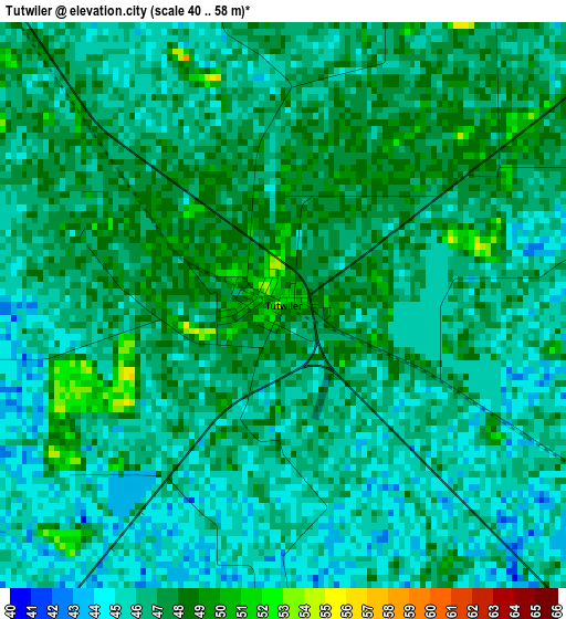
Below is the Elevation map of Tutwiler, which displays elevation range with different colors. Scale of the first map is from 40 to 58 m (131 to 190 ft) with average elevation of 46.2 meters (=152 ft) [note 1]
These maps also provides idea of topography and contour of this city, they are displayed at different zoom levels. More info about maps, scale and edge coordinates you can find below images.
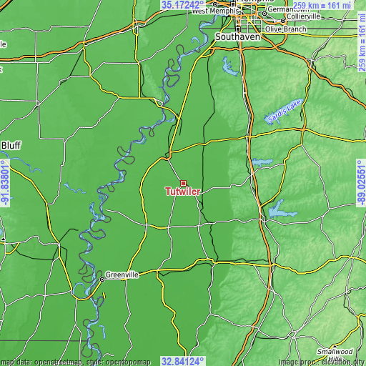
| \ | Map #1 | Topo.Map |
| Scale [m] | 40..58 m | × |
| Scale [ft] | 131..190 ft | × |
| Average | 46.2 m = 152 ft | × |
| Width | 8.1 km = 5 mi | 259.2 km = 161.1 mi |
| Height | 8.1 km = 5 mi | 259.2 km = 161.1 mi |
| ↑Max Latitude | 34.051248° | 35.17242° |
| Latitude at center | 34.01483° | 34.01483° |
| ↓Min Latitude | 33.978396° | 32.84124° |
| ← Min Longitude | -90.475705° | -91.83801° |
| Longitude center | -90.43176° | -90.43176° |
| →Max Longitude | -90.387815° | -89.02551° |
Nearby cities:
Cities around Tutwiler sort by population:
• Clarksdale elevation 54 m
24.3 km,  328°
328°
• Cleveland 43 m
40.5 km,  221°
221°
• Ruleville 41 m
34 km,  198°
198°
• Shelby 47 m
31.8 km,  257°
257°
• Charleston 62 m
34.6 km,  91°
91°
• Drew 42 m
24.4 km, 200°
• Marks 49 m
30.6 km,  28°
28°
• Lambert 48 m
24.9 km, 33°
• Mound Bayou 44 m
31.2 km,  240°
240°
• Jonestown 51 m
34 km,  356°
356°
• Mikoma 45 m
15.4 km,  117°
117°
• Friars Point 52 m
43.9 km, 334°
Multilingual:
 En español:
Tutwiler elevación 51 m.
 En France:
Tutwiler élévation 51 m.


Sources and notes:
- [note 1] Map square and city borders are not equal. Map elevation data is calculated only from area inside that square.
- [src 1] Elevation data from geonames database provided with same terms of usage.
- [src 2] The elevation map of Tutwiler is generated using elevation data from NASA's 3 arcsec (90m) resolution SRTM data.
- [src 3] Base (background) map © OpenStreetMap contributors tiles are generated by Geofabrik and OpenTopoMap.
Copyright & License:
This Tutwiler Elevation Map is licensed under CC BY-SA. You may reuse any part from this page, if you give a proper credit by linking to this URL:
 More info on terms of use page.