McComb elevation
McComb (Mississippi, Pike County), United States elevation is 131 meters and McComb elevation in feet is 430 ft above sea level [src 1]. McComb is a populated place (feature code) with elevation that is 148 meters (486 ft) smaller than average city elevation in United States.
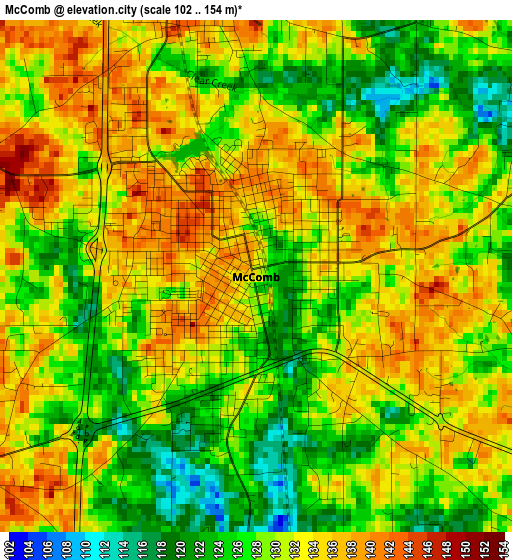
Below is the Elevation map of McComb, which displays elevation range with different colors. Scale of the first map is from 102 to 154 m (335 to 505 ft) with average elevation of 130.1 meters (=427 ft) [note 1]
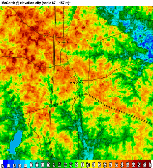
These maps also provides idea of topography and contour of this city, they are displayed at different zoom levels. More info about maps, scale and edge coordinates you can find below images.
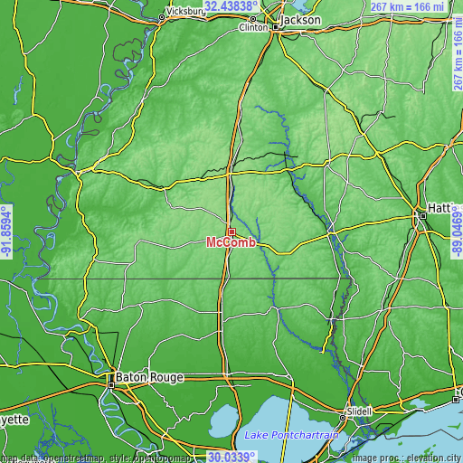
| \ | Map #1 | Map #2 | Topo.Map |
| Scale [m] | 102..154 m | 87..157 m | × |
| Scale [ft] | 335..505 ft | 285..515 ft | × |
| Average | 130.1 m = 427 ft | 126.1 m = 414 ft | × |
| Width | 8.36 km = 5.2 mi | 16.71 km = 10.4 mi | 267.4 km = 166.2 mi |
| Height | 8.36 km = 5.2 mi | 16.71 km = 10.4 mi | 267.4 km = 166.2 mi |
| ↑Max Latitude | 31.281354° | 31.318904° | 32.43838° |
| Latitude at center | 31.24379° | 31.24379° | 31.24379° |
| ↓Min Latitude | 31.206211° | 31.168616° | 30.0339° |
| ← Min Longitude | -90.497095° | -90.541041° | -91.8594° |
| Longitude center | -90.45315° | -90.45315° | -90.45315° |
| →Max Longitude | -90.409205° | -90.365259° | -89.0469° |
Nearby cities:
Cities around McComb sort by population:
• Brookhaven elevation 153 m
37.3 km,  1°
1°
• Holly Springs 99 m
45.9 km,  79°
79°
• Magnolia 93 m
11.2 km,  182°
182°
• Kentwood 66 m
34.4 km,  188°
188°
• Wesson 146 m
51.1 km,  5°
5°
• Summit 133 m
4.7 km,  341°
341°
• Monticello 60 m
47.6 km,  43°
43°
• Tylertown 91 m
32.8 km,  115°
115°
• Bude 76 m
44.9 km,  302°
302°
• Liberty 112 m
35.5 km,  254°
254°
• Greensburg 73 m
50.4 km,  204°
204°
• Meadville 101 m
49.2 km, 301°
Multilingual:
 En español:
McComb elevación 131 m.
 En France:
McComb élévation 131 m.


Sources and notes:
- [note 1] Map square and city borders are not equal. Map elevation data is calculated only from area inside that square.
- [src 1] Elevation data from geonames database provided with same terms of usage.
- [src 2] The elevation map of McComb is generated using elevation data from NASA's 3 arcsec (90m) resolution SRTM data.
- [src 3] Base (background) map © OpenStreetMap contributors tiles are generated by Geofabrik and OpenTopoMap.
Copyright & License:
This McComb Elevation Map is licensed under CC BY-SA. You may reuse any part from this page, if you give a proper credit by linking to this URL:
 More info on terms of use page.