Magee elevation
Magee (Mississippi, Simpson County), United States elevation is 136 meters and Magee elevation in feet is 446 ft above sea level [src 1]. Magee is a populated place (feature code) with elevation that is 143 meters (469 ft) smaller than average city elevation in United States.
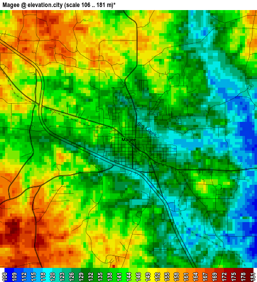
Below is the Elevation map of Magee, which displays elevation range with different colors. Scale of the first map is from 106 to 181 m (348 to 594 ft) with average elevation of 139.5 meters (=458 ft) [note 1]
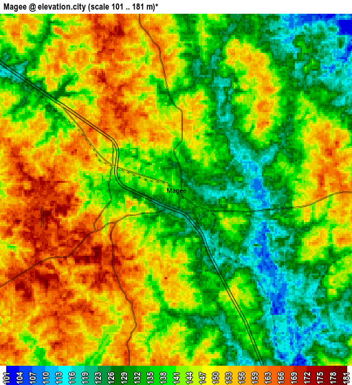
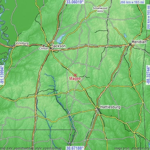
These maps also provides idea of topography and contour of this city, they are displayed at different zoom levels. More info about maps, scale and edge coordinates you can find below images.
| \ | Map #1 | Map #2 | Topo.Map |
| Scale [m] | 106..181 m | 101..181 m | × |
| Scale [ft] | 348..594 ft | 331..594 ft | × |
| Average | 139.5 m = 458 ft | 142.4 m = 467 ft | × |
| Width | 8.3 km = 5.2 mi | 16.6 km = 10.3 mi | 265.6 km = 165 mi |
| Height | 8.3 km = 5.2 mi | 16.6 km = 10.3 mi | 265.6 km = 165 mi |
| ↑Max Latitude | 31.911081° | 31.948378° | 33.06019° |
| Latitude at center | 31.87377° | 31.87377° | 31.87377° |
| ↓Min Latitude | 31.836443° | 31.799102° | 30.67188° |
| ← Min Longitude | -89.777635° | -89.821581° | -91.13994° |
| Longitude center | -89.73369° | -89.73369° | -89.73369° |
| →Max Longitude | -89.689745° | -89.645799° | -88.32744° |
Nearby cities:
Cities around Magee sort by population:
• Brandon elevation 147 m
50.4 km,  331°
331°
• Florence 98 m
48.7 km,  309°
309°
• Morton 152 m
53.9 km,  7°
7°
• Collins 89 m
30.5 km,  146°
146°
• Mendenhall 103 m
16.2 km, 307°
• Bay Springs 130 m
43.7 km,  74°
74°
• Cleary 122 m
53.2 km, 307°
• Monticello 60 m
50.1 km,  224°
224°
• Raleigh 165 m
26.7 km,  48°
48°
• Pelahatchie 114 m
49.2 km,  352°
352°
• Taylorsville 87 m
29.3 km,  99°
99°
• Prentiss 105 m
33.1 km,  202°
202°
Multilingual:
 En español:
Magee elevación 136 m.
 En France:
Magee élévation 136 m.


Sources and notes:
- [note 1] Map square and city borders are not equal. Map elevation data is calculated only from area inside that square.
- [src 1] Elevation data from geonames database provided with same terms of usage.
- [src 2] The elevation map of Magee is generated using elevation data from NASA's 3 arcsec (90m) resolution SRTM data.
- [src 3] Base (background) map © OpenStreetMap contributors tiles are generated by Geofabrik and OpenTopoMap.
Copyright & License:
This Magee Elevation Map is licensed under CC BY-SA. You may reuse any part from this page, if you give a proper credit by linking to this URL:
 More info on terms of use page.