Hazlehurst elevation
Hazlehurst (Mississippi, Copiah County), United States elevation is 147 meters and Hazlehurst elevation in feet is 482 ft above sea level [src 1]. Hazlehurst is a seat of a second-order administrative division (feature code) with elevation that is 132 meters (433 ft) smaller than average city elevation in United States.
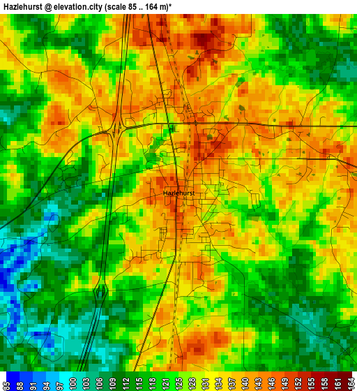
Below is the Elevation map of Hazlehurst, which displays elevation range with different colors. Scale of the first map is from 85 to 164 m (279 to 538 ft) with average elevation of 126.4 meters (=415 ft) [note 1]
These maps also provides idea of topography and contour of this city, they are displayed at different zoom levels. More info about maps, scale and edge coordinates you can find below images.
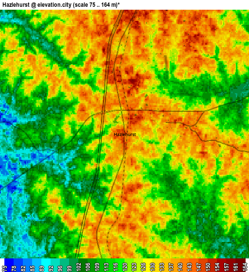
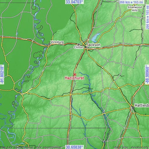
| \ | Map #1 | Map #2 | Topo.Map |
| Scale [m] | 85..164 m | 75..164 m | × |
| Scale [ft] | 279..538 ft | 246..538 ft | × |
| Average | 126.4 m = 415 ft | 122.1 m = 401 ft | × |
| Width | 8.3 km = 5.2 mi | 16.6 km = 10.3 mi | 265.6 km = 165 mi |
| Height | 8.3 km = 5.2 mi | 16.6 km = 10.3 mi | 265.6 km = 165 mi |
| ↑Max Latitude | 31.897757° | 31.935058° | 33.04703° |
| Latitude at center | 31.86044° | 31.86044° | 31.86044° |
| ↓Min Latitude | 31.823108° | 31.785761° | 30.65838° |
| ← Min Longitude | -90.439875° | -90.483821° | -91.80218° |
| Longitude center | -90.39593° | -90.39593° | -90.39593° |
| →Max Longitude | -90.351985° | -90.308039° | -88.98968° |
Nearby cities:
Cities around Hazlehurst sort by population:
• Pearl elevation 89 m
52.3 km,  28°
28°
• Brookhaven 153 m
31.6 km,  187°
187°
• Byram 81 m
38.2 km,  21°
21°
• Richland 85 m
47.7 km, 28°
• Crystal Springs 144 m
14.6 km,  14°
14°
• Florence 98 m
41 km,  37°
37°
• Mendenhall 103 m
50.9 km,  77°
77°
• Raymond 104 m
44.4 km,  356°
356°
• Wesson 146 m
17.7 km,  180°
180°
• Cleary 122 m
39.5 km, 30°
• Monticello 60 m
43.7 km,  141°
141°
• Terry 95 m
27.9 km, 20°
Multilingual:
 En español:
Hazlehurst elevación 147 m.
 En France:
Hazlehurst élévation 147 m.
 Auf Deutsch:
Hazlehurst höhe über dem Meeresspiegel ist 147 m.

Sources and notes:
- [note 1] Map square and city borders are not equal. Map elevation data is calculated only from area inside that square.
- [src 1] Elevation data from geonames database provided with same terms of usage.
- [src 2] The elevation map of Hazlehurst is generated using elevation data from NASA's 3 arcsec (90m) resolution SRTM data.
- [src 3] Base (background) map © OpenStreetMap contributors tiles are generated by Geofabrik and OpenTopoMap.
Copyright & License:
This Hazlehurst Elevation Map is licensed under CC BY-SA. You may reuse any part from this page, if you give a proper credit by linking to this URL:
 More info on terms of use page.