University City elevation
University City (Missouri, Saint Louis County), United States elevation is 160 meters and University City elevation in feet is 525 ft above sea level [src 1]. University City is a populated place (feature code) with elevation that is 119 meters (390 ft) smaller than average city elevation in United States.
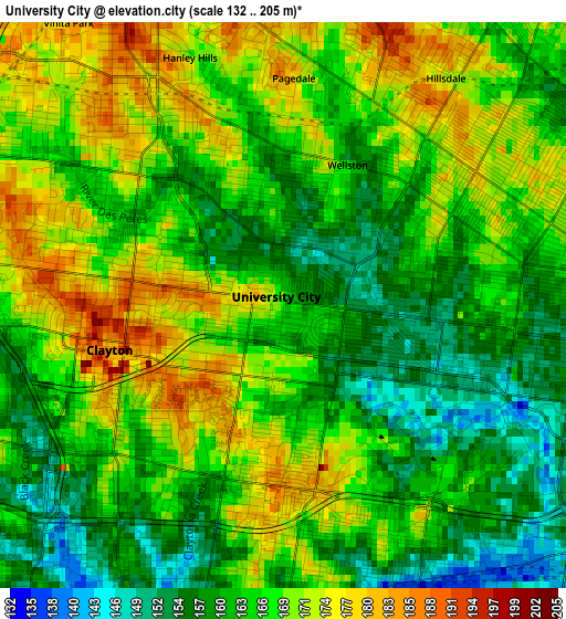
Below is the Elevation map of University City, which displays elevation range with different colors. Scale of the first map is from 132 to 205 m (433 to 673 ft) with average elevation of 165.7 meters (=544 ft) [note 1]
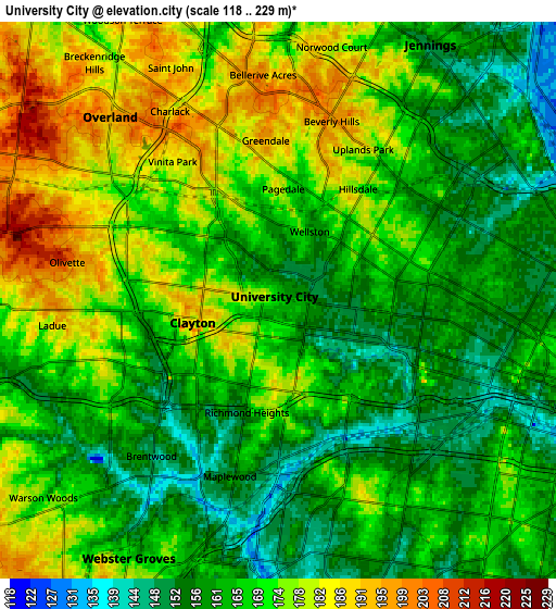
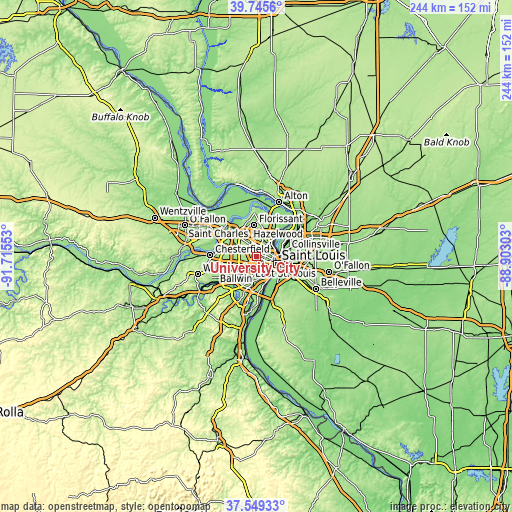
These maps also provides idea of topography and contour of this city, they are displayed at different zoom levels. More info about maps, scale and edge coordinates you can find below images.
| \ | Map #1 | Map #2 | Topo.Map |
| Scale [m] | 132..205 m | 118..229 m | × |
| Scale [ft] | 433..673 ft | 387..751 ft | × |
| Average | 165.7 m = 544 ft | 168.1 m = 552 ft | × |
| Width | 7.63 km = 4.7 mi | 15.26 km = 9.5 mi | 244.2 km = 151.7 mi |
| Height | 7.63 km = 4.7 mi | 15.26 km = 9.5 mi | 244.2 km = 151.7 mi |
| ↑Max Latitude | 38.690189° | 38.724482° | 39.7456° |
| Latitude at center | 38.65588° | 38.65588° | 38.65588° |
| ↓Min Latitude | 38.621554° | 38.587212° | 37.54933° |
| ← Min Longitude | -90.353225° | -90.397171° | -91.71553° |
| Longitude center | -90.30928° | -90.30928° | -90.30928° |
| →Max Longitude | -90.265335° | -90.221389° | -88.90303° |
Nearby cities:
Cities around University City sort by population:
• Clayton elevation 175 m
1.9 km,  220°
220°
• Richmond Heights 163 m
3.2 km,  196°
196°
• Maplewood 152 m
5 km, 195°
• Pine Lawn 190 m
5.3 km,  33°
33°
• Pagedale 178 m
3.1 km,  2°
2°
• Wellston 161 m
2.1 km,  24°
24°
• Hanley Hills 169 m
3.6 km,  339°
339°
• Vinita Park 185 m
4.8 km,  322°
322°
• Hillsdale 172 m
3.8 km,  35°
35°
• Bel-Nor 196 m
5.2 km,  352°
352°
• Velda Village 191 m
4 km, 18°
• Velda Village Hills 177 m
4.3 km, 26°
Multilingual:
 En español:
University City elevación 160 m.
 En France:
University City élévation 160 m.
 Auf Deutsch:
University City höhe über dem Meeresspiegel ist 160 m.

Sources and notes:
- [note 1] Map square and city borders are not equal. Map elevation data is calculated only from area inside that square.
- [src 1] Elevation data from geonames database provided with same terms of usage.
- [src 2] The elevation map of University City is generated using elevation data from NASA's 3 arcsec (90m) resolution SRTM data.
- [src 3] Base (background) map © OpenStreetMap contributors tiles are generated by Geofabrik and OpenTopoMap.
Copyright & License:
This University City Elevation Map is licensed under CC BY-SA. You may reuse any part from this page, if you give a proper credit by linking to this URL:
 More info on terms of use page.