Mount Vernon elevation
Mount Vernon (Missouri, Lawrence County), United States elevation is 377 meters and Mount Vernon elevation in feet is 1237 ft above sea level [src 1]. Mount Vernon is a seat of a second-order administrative division (feature code) with elevation that is 98 meters (322 ft) bigger than average city elevation in United States.
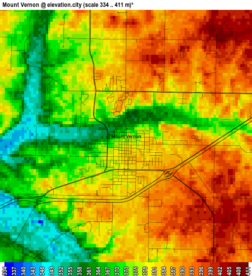
Below is the Elevation map of Mount Vernon, which displays elevation range with different colors. Scale of the first map is from 334 to 411 m (1096 to 1348 ft) with average elevation of 379.8 meters (=1246 ft) [note 1]
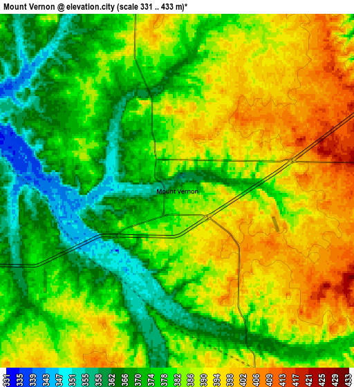
These maps also provides idea of topography and contour of this city, they are displayed at different zoom levels. More info about maps, scale and edge coordinates you can find below images.
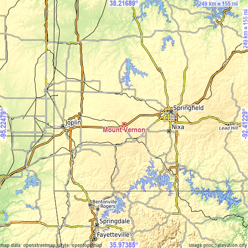
| \ | Map #1 | Map #2 | Topo.Map |
| Scale [m] | 334..411 m | 331..433 m | × |
| Scale [ft] | 1096..1348 ft | 1086..1421 ft | × |
| Average | 379.8 m = 1246 ft | 381.5 m = 1252 ft | × |
| Width | 7.79 km = 4.8 mi | 15.59 km = 9.7 mi | 249.4 km = 155 mi |
| Height | 7.79 km = 4.8 mi | 15.59 km = 9.7 mi | 249.4 km = 155 mi |
| ↑Max Latitude | 37.13871° | 37.173734° | 38.21689° |
| Latitude at center | 37.10367° | 37.10367° | 37.10367° |
| ↓Min Latitude | 37.068614° | 37.033541° | 35.97385° |
| ← Min Longitude | -93.862485° | -93.906431° | -95.22479° |
| Longitude center | -93.81854° | -93.81854° | -93.81854° |
| →Max Longitude | -93.774595° | -93.730649° | -92.41229° |
Nearby cities:
Cities around Mount Vernon sort by population:
• Republic elevation 402 m
30.1 km,  86°
86°
• Monett 414 m
21.7 km,  206°
206°
• Aurora 430 m
17.3 km,  148°
148°
• Clever 430 m
31.7 km,  104°
104°
• Marionville 419 m
19.6 km,  124°
124°
• Ash Grove 325 m
31.3 km,  41°
41°
• Crane 351 m
31.1 km,  135°
135°
• Greenfield 339 m
34.7 km,  356°
356°
• Sarcoxie 336 m
26.7 km,  261°
261°
• Pierce City 374 m
23.8 km,  222°
222°
• Purdy 455 m
33.1 km,  195°
195°
• Billings 421 m
24 km, 99°
Multilingual:
 En español:
Mount Vernon elevación 377 m.
 En France:
Mount Vernon élévation 377 m.
 Auf Deutsch:
Mount Vernon höhe über dem Meeresspiegel ist 377 m.

Sources and notes:
- [note 1] Map square and city borders are not equal. Map elevation data is calculated only from area inside that square.
- [src 1] Elevation data from geonames database provided with same terms of usage.
- [src 2] The elevation map of Mount Vernon is generated using elevation data from NASA's 3 arcsec (90m) resolution SRTM data.
- [src 3] Base (background) map © OpenStreetMap contributors tiles are generated by Geofabrik and OpenTopoMap.
Copyright & License:
This Mount Vernon Elevation Map is licensed under CC BY-SA. You may reuse any part from this page, if you give a proper credit by linking to this URL:
 More info on terms of use page.