Fenton elevation
Fenton (Missouri, Saint Louis County), United States elevation is 132 meters and Fenton elevation in feet is 433 ft above sea level [src 1]. Fenton is a populated place (feature code) with elevation that is 147 meters (482 ft) smaller than average city elevation in United States.
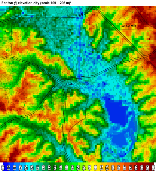
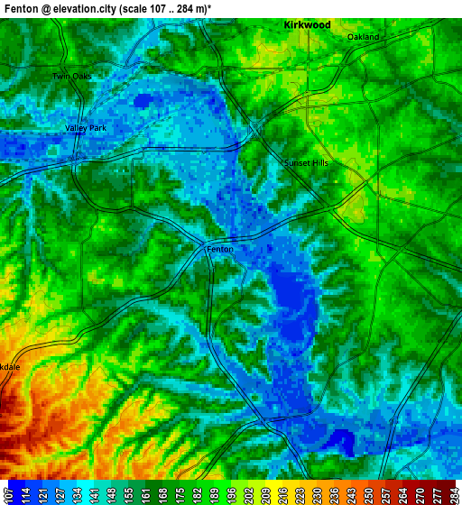
Below is the Elevation map of Fenton, which displays elevation range with different colors. Scale of the first map is from 109 to 206 m (358 to 676 ft) with average elevation of 151.6 meters (=497 ft) [note 1]
These maps also provides idea of topography and contour of this city, they are displayed at different zoom levels. More info about maps, scale and edge coordinates you can find below images.
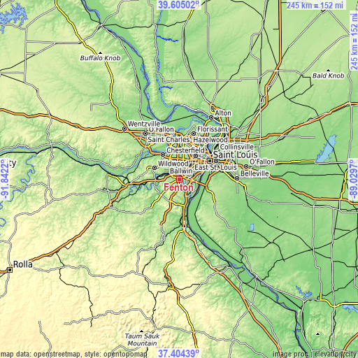
| \ | Map #1 | Map #2 | Topo.Map |
| Scale [m] | 109..206 m | 107..284 m | × |
| Scale [ft] | 358..676 ft | 351..932 ft | × |
| Average | 151.6 m = 497 ft | 167.2 m = 549 ft | × |
| Width | 7.65 km = 4.8 mi | 15.29 km = 9.5 mi | 244.7 km = 152 mi |
| Height | 7.65 km = 4.8 mi | 15.29 km = 9.5 mi | 244.7 km = 152 mi |
| ↑Max Latitude | 38.547487° | 38.581849° | 39.60502° |
| Latitude at center | 38.51311° | 38.51311° | 38.51311° |
| ↓Min Latitude | 38.478716° | 38.444306° | 37.40439° |
| ← Min Longitude | -90.479895° | -90.523841° | -91.8422° |
| Longitude center | -90.43595° | -90.43595° | -90.43595° |
| →Max Longitude | -90.392005° | -90.348059° | -89.0297° |
Nearby cities:
Cities around Fenton sort by population:
• Kirkwood elevation 204 m
8.2 km,  17°
17°
• Affton 188 m
9.9 km,  64°
64°
• Concord 190 m
7 km,  79°
79°
• Crestwood 188 m
6.8 km,  43°
43°
• Murphy 173 m
5.1 km,  240°
240°
• Des Peres 183 m
9.8 km,  1°
1°
• Sunset Hills 188 m
3.8 km, 40°
• Sappington 183 m
5.6 km, 61°
• Valley Park 131 m
6.4 km,  309°
309°
• Green Park 170 m
8.6 km, 82°
• Lakeshire 178 m
9.2 km,  72°
72°
• Oakland 186 m
8.3 km,  31°
31°
Multilingual:
 En español:
Fenton elevación 132 m.
 En France:
Fenton élévation 132 m.


Sources and notes:
- [note 1] Map square and city borders are not equal. Map elevation data is calculated only from area inside that square.
- [src 1] Elevation data from geonames database provided with same terms of usage.
- [src 2] The elevation map of Fenton is generated using elevation data from NASA's 3 arcsec (90m) resolution SRTM data.
- [src 3] Base (background) map © OpenStreetMap contributors tiles are generated by Geofabrik and OpenTopoMap.
Copyright & License:
This Fenton Elevation Map is licensed under CC BY-SA. You may reuse any part from this page, if you give a proper credit by linking to this URL:
 More info on terms of use page.