Branson elevation
Branson (Missouri, Taney County), United States elevation is 238 meters and Branson elevation in feet is 781 ft above sea level [src 1]. Branson is a populated place (feature code) with elevation that is 41 meters (135 ft) smaller than average city elevation in United States.
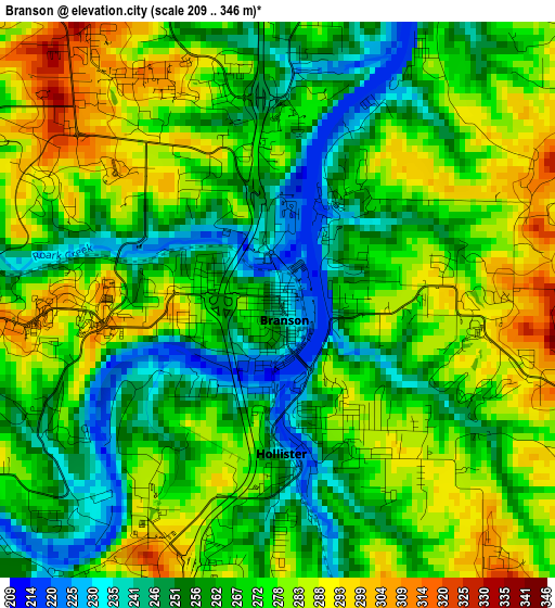
Below is the Elevation map of Branson, which displays elevation range with different colors. Scale of the first map is from 209 to 346 m (686 to 1135 ft) with average elevation of 269.2 meters (=883 ft) [note 1]
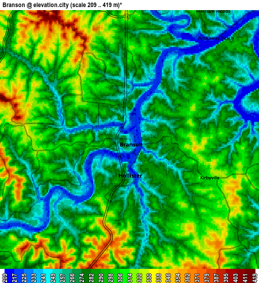
These maps also provides idea of topography and contour of this city, they are displayed at different zoom levels. More info about maps, scale and edge coordinates you can find below images.
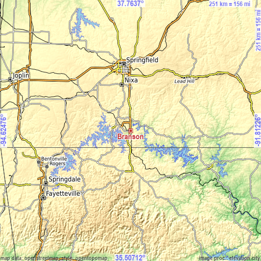
| \ | Map #1 | Map #2 | Topo.Map |
| Scale [m] | 209..346 m | 209..419 m | × |
| Scale [ft] | 686..1135 ft | 686..1375 ft | × |
| Average | 269.2 m = 883 ft | 288.3 m = 946 ft | × |
| Width | 7.84 km = 4.9 mi | 15.68 km = 9.7 mi | 250.9 km = 155.9 mi |
| Height | 7.84 km = 4.9 mi | 15.68 km = 9.7 mi | 250.9 km = 155.9 mi |
| ↑Max Latitude | 36.678922° | 36.714158° | 37.7637° |
| Latitude at center | 36.64367° | 36.64367° | 36.64367° |
| ↓Min Latitude | 36.608402° | 36.573118° | 35.50712° |
| ← Min Longitude | -93.262455° | -93.306401° | -94.62476° |
| Longitude center | -93.21851° | -93.21851° | -93.21851° |
| →Max Longitude | -93.174565° | -93.130619° | -91.81226° |
Nearby cities:
Cities around Branson sort by population:
• Ozark elevation 360 m
42 km,  1°
1°
• Berryville 381 m
44 km,  225°
225°
• Hollister 226 m
2.5 km,  173°
173°
• Green Forest 412 m
39.4 km,  209°
209°
• Forsyth 285 m
9.9 km,  62°
62°
• Kimberling City 295 m
17.7 km,  266°
266°
• Sparta 432 m
41.6 km,  17°
17°
• Merriam Woods 270 m
9.3 km,  32°
32°
• Shell Knob 356 m
37.1 km, 268°
• Crane 351 m
42.8 km,  312°
312°
• Kissee Mills 304 m
15.7 km,  73°
73°
• Galena 310 m
28.5 km, 309°
Multilingual:
 En español:
Branson elevación 238 m.
 En France:
Branson élévation 238 m.


Sources and notes:
- [note 1] Map square and city borders are not equal. Map elevation data is calculated only from area inside that square.
- [src 1] Elevation data from geonames database provided with same terms of usage.
- [src 2] The elevation map of Branson is generated using elevation data from NASA's 3 arcsec (90m) resolution SRTM data.
- [src 3] Base (background) map © OpenStreetMap contributors tiles are generated by Geofabrik and OpenTopoMap.
Copyright & License:
This Branson Elevation Map is licensed under CC BY-SA. You may reuse any part from this page, if you give a proper credit by linking to this URL:
 More info on terms of use page.