Mount Rainier elevation
Mount Rainier (Maryland, Prince George's County), United States elevation is 29 meters and Mount Rainier elevation in feet is 95 ft above sea level [src 1]. Mount Rainier is a populated place (feature code) with elevation that is 250 meters (820 ft) smaller than average city elevation in United States.
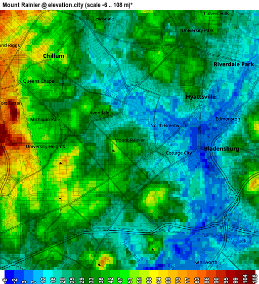
Below is the Elevation map of Mount Rainier, which displays elevation range with different colors. Scale of the first map is from -6 to 108 m (-20 to 354 ft) with average elevation of 30.7 meters (=101 ft) [note 1]
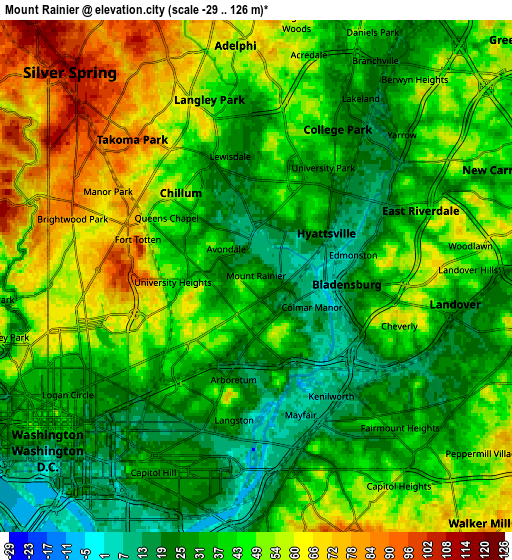
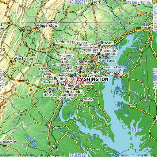
These maps also provides idea of topography and contour of this city, they are displayed at different zoom levels. More info about maps, scale and edge coordinates you can find below images.
| \ | Map #1 | Map #2 | Topo.Map |
| Scale [m] | -6..108 m | -29..126 m | × |
| Scale [ft] | -20..354 ft | -95..413 ft | × |
| Average | 30.7 m = 101 ft | 42.2 m = 138 ft | × |
| Width | 7.6 km = 4.7 mi | 15.2 km = 9.4 mi | 243.2 km = 151.1 mi |
| Height | 7.6 km = 4.7 mi | 15.2 km = 9.4 mi | 243.2 km = 151.1 mi |
| ↑Max Latitude | 38.975672° | 39.009827° | 40.02681° |
| Latitude at center | 38.9415° | 38.9415° | 38.9415° |
| ↓Min Latitude | 38.907312° | 38.873107° | 37.83932° |
| ← Min Longitude | -77.008925° | -77.052871° | -78.37123° |
| Longitude center | -76.96498° | -76.96498° | -76.96498° |
| →Max Longitude | -76.921035° | -76.877089° | -75.55873° |
Nearby cities:
Cities around Mount Rainier sort by population:
• Chillum elevation 48 m
3.3 km,  317°
317°
• Hyattsville 37 m
2.3 km,  46°
46°
• East Riverdale 13 m
4.4 km,  58°
58°
• Bladensburg 16 m
2.7 km,  95°
95°
• Riverdale Park 17 m
3.8 km, 49°
• Cheverly 58 m
4.5 km,  109°
109°
• Bloomingdale 30 m
4.9 km,  235°
235°
• Brentwood 8 m
0.7 km,  75°
75°
• University Park 28 m
3.8 km,  31°
31°
• Edmonston 9 m
3 km, 78°
• Colmar Manor 11 m
1.9 km,  119°
119°
• Cottage City 12 m
1.5 km, 104°
Multilingual:
 En español:
Mount Rainier elevación 29 m.
 En France:
Mount Rainier élévation 29 m.
 Auf Deutsch:
Mount Rainier höhe über dem Meeresspiegel ist 29 m.

Sources and notes:
- [note 1] Map square and city borders are not equal. Map elevation data is calculated only from area inside that square.
- [src 1] Elevation data from geonames database provided with same terms of usage.
- [src 2] The elevation map of Mount Rainier is generated using elevation data from NASA's 3 arcsec (90m) resolution SRTM data.
- [src 3] Base (background) map © OpenStreetMap contributors tiles are generated by Geofabrik and OpenTopoMap.
Copyright & License:
This Mount Rainier Elevation Map is licensed under CC BY-SA. You may reuse any part from this page, if you give a proper credit by linking to this URL:
 More info on terms of use page.