Irvington elevation
Irvington (Maryland, City of Baltimore), United States elevation is 73 meters and Irvington elevation in feet is 240 ft above sea level [src 1]. Irvington is a section of populated place (feature code) with elevation that is 206 meters (676 ft) smaller than average city elevation in United States.
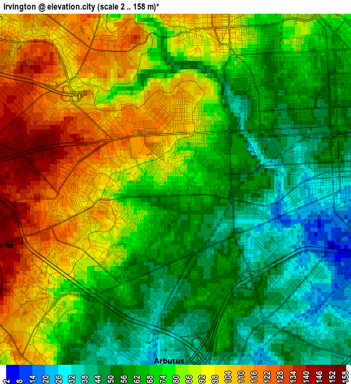
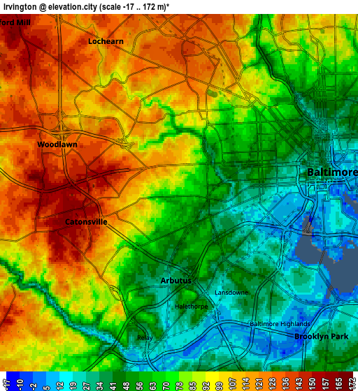
Below is the Elevation map of Irvington, which displays elevation range with different colors. Scale of the first map is from 2 to 158 m (7 to 518 ft) with average elevation of 75.5 meters (=248 ft) [note 1]
These maps also provides idea of topography and contour of this city, they are displayed at different zoom levels. More info about maps, scale and edge coordinates you can find below images.
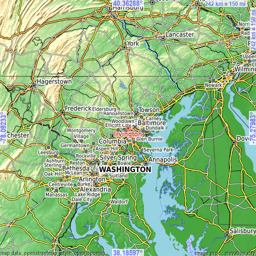
| \ | Map #1 | Map #2 | Topo.Map |
| Scale [m] | 2..158 m | -17..172 m | × |
| Scale [ft] | 7..518 ft | -56..564 ft | × |
| Average | 75.5 m = 248 ft | 79 m = 259 ft | × |
| Width | 7.56 km = 4.7 mi | 15.13 km = 9.4 mi | 242 km = 150.4 mi |
| Height | 7.56 km = 4.7 mi | 15.13 km = 9.4 mi | 242 km = 150.4 mi |
| ↑Max Latitude | 39.316887° | 39.350877° | 40.36288° |
| Latitude at center | 39.28288° | 39.28288° | 39.28288° |
| ↓Min Latitude | 39.248857° | 39.214817° | 38.18597° |
| ← Min Longitude | -76.730025° | -76.773971° | -78.09233° |
| Longitude center | -76.68608° | -76.68608° | -76.68608° |
| →Max Longitude | -76.642135° | -76.598189° | -75.27983° |
Nearby cities:
Cities around Irvington sort by population:
• Baltimore elevation 35 m
6.4 km,  82°
82°
• Catonsville 146 m
4.1 km,  253°
253°
• Woodlawn 104 m
5.7 km,  320°
320°
• Lochearn 128 m
7.1 km,  334°
334°
• Ilchester 44 m
7.6 km,  242°
242°
• Arbutus 46 m
3.4 km,  200°
200°
• Elkridge 37 m
8.2 km, 196°
• Lansdowne 25 m
4.7 km,  152°
152°
• Charles Village 68 m
7.7 km,  54°
54°
• Baltimore Highlands 12 m
7 km,  142°
142°
• Arlington 135 m
7.3 km,  1°
1°
• Charlestown 97 m
2.3 km,  225°
225°
Multilingual:
 En español:
Irvington elevación 73 m.
 En France:
Irvington élévation 73 m.
 Auf Deutsch:
Irvington höhe über dem Meeresspiegel ist 73 m.

Sources and notes:
- [note 1] Map square and city borders are not equal. Map elevation data is calculated only from area inside that square.
- [src 1] Elevation data from geonames database provided with same terms of usage.
- [src 2] The elevation map of Irvington is generated using elevation data from NASA's 3 arcsec (90m) resolution SRTM data.
- [src 3] Base (background) map © OpenStreetMap contributors tiles are generated by Geofabrik and OpenTopoMap.
Copyright & License:
This Irvington Elevation Map is licensed under CC BY-SA. You may reuse any part from this page, if you give a proper credit by linking to this URL:
 More info on terms of use page.