Cumberland elevation
Cumberland (Maryland, Allegany County), United States elevation is 190 meters and Cumberland elevation in feet is 623 ft above sea level [src 1]. Cumberland is a seat of a second-order administrative division (feature code) with elevation that is 89 meters (292 ft) smaller than average city elevation in United States.
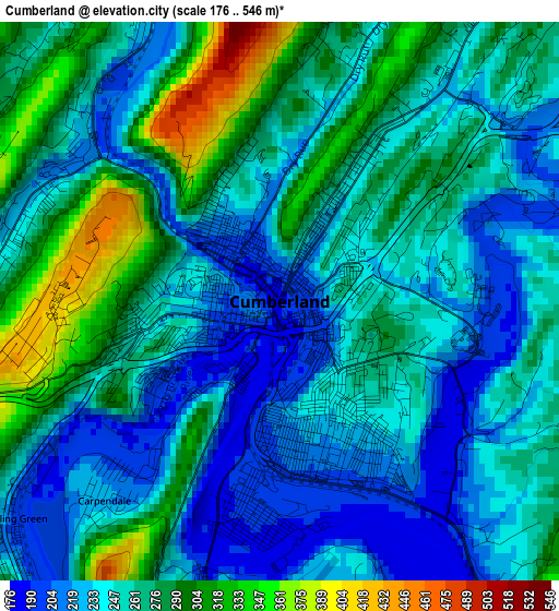
Below is the Elevation map of Cumberland, which displays elevation range with different colors. Scale of the first map is from 176 to 546 m (577 to 1791 ft) with average elevation of 257.5 meters (=845 ft) [note 1]
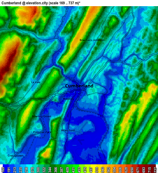
These maps also provides idea of topography and contour of this city, they are displayed at different zoom levels. More info about maps, scale and edge coordinates you can find below images.
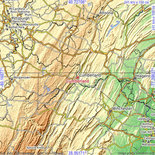
| \ | Map #1 | Map #2 | Topo.Map |
| Scale [m] | 176..546 m | 169..737 m | × |
| Scale [ft] | 577..1791 ft | 554..2418 ft | × |
| Average | 257.5 m = 845 ft | 316 m = 1037 ft | × |
| Width | 7.52 km = 4.7 mi | 15.05 km = 9.4 mi | 240.8 km = 149.6 mi |
| Height | 7.52 km = 4.7 mi | 15.05 km = 9.4 mi | 240.8 km = 149.6 mi |
| ↑Max Latitude | 39.686696° | 39.720506° | 40.72708° |
| Latitude at center | 39.65287° | 39.65287° | 39.65287° |
| ↓Min Latitude | 39.619027° | 39.585168° | 38.56171° |
| ← Min Longitude | -78.806465° | -78.850411° | -80.16877° |
| Longitude center | -78.76252° | -78.76252° | -78.76252° |
| →Max Longitude | -78.718575° | -78.674629° | -77.35627° |
Nearby cities:
Cities around Cumberland sort by population:
• Frostburg elevation 629 m
14.2 km,  272°
272°
• Keyser 246 m
29.7 km,  217°
217°
• Cresaptown 232 m
9 km, 222°
• La Vale 239 m
4.1 km, 274°
• Potomac Park 223 m
5.9 km, 219°
• Meyersdale 604 m
28.7 km,  308°
308°
• Westernport 278 m
30.5 km,  232°
232°
• Fort Ashby 181 m
16.7 km,  181°
181°
• Bel Air 212 m
11.6 km, 220°
• Lonaconing 457 m
21 km,  242°
242°
• Bowling Green 203 m
4.8 km, 227°
• Wiley Ford 214 m
4.4 km,  194°
194°
Multilingual:
 En español:
Cumberland elevación 190 m.
 En France:
Cumberland élévation 190 m.
 Auf Deutsch:
Cumberland höhe über dem Meeresspiegel ist 190 m.

Sources and notes:
- [note 1] Map square and city borders are not equal. Map elevation data is calculated only from area inside that square.
- [src 1] Elevation data from geonames database provided with same terms of usage.
- [src 2] The elevation map of Cumberland is generated using elevation data from NASA's 3 arcsec (90m) resolution SRTM data.
- [src 3] Base (background) map © OpenStreetMap contributors tiles are generated by Geofabrik and OpenTopoMap.
Copyright & License:
This Cumberland Elevation Map is licensed under CC BY-SA. You may reuse any part from this page, if you give a proper credit by linking to this URL:
 More info on terms of use page.