Cape Saint Claire elevation
Cape Saint Claire (Maryland, Anne Arundel County), United States elevation is 28 meters and Cape Saint Claire elevation in feet is 92 ft above sea level [src 1]. Cape Saint Claire is a populated place (feature code) with elevation that is 251 meters (823 ft) smaller than average city elevation in United States.
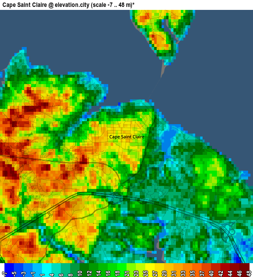
Below is the Elevation map of Cape Saint Claire, which displays elevation range with different colors. Scale of the first map is from -7 to 48 m (-23 to 157 ft) with average elevation of 17.9 meters (=59 ft) [note 1]
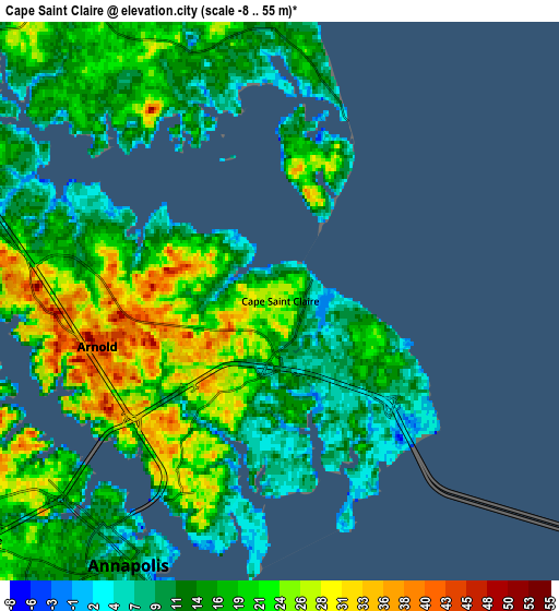
These maps also provides idea of topography and contour of this city, they are displayed at different zoom levels. More info about maps, scale and edge coordinates you can find below images.
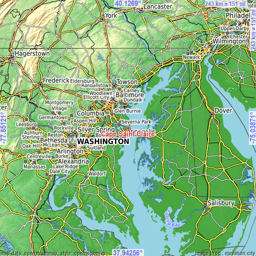
| \ | Map #1 | Map #2 | Topo.Map |
| Scale [m] | -7..48 m | -8..55 m | × |
| Scale [ft] | -23..157 ft | -26..180 ft | × |
| Average | 17.9 m = 59 ft | 17.1 m = 56 ft | × |
| Width | 7.59 km = 4.7 mi | 15.18 km = 9.4 mi | 242.9 km = 150.9 mi |
| Height | 7.59 km = 4.7 mi | 15.18 km = 9.4 mi | 242.9 km = 150.9 mi |
| ↑Max Latitude | 39.077293° | 39.111399° | 40.1269° |
| Latitude at center | 39.04317° | 39.04317° | 39.04317° |
| ↓Min Latitude | 39.009031° | 38.974875° | 37.94256° |
| ← Min Longitude | -76.488905° | -76.532851° | -77.85121° |
| Longitude center | -76.44496° | -76.44496° | -76.44496° |
| →Max Longitude | -76.401015° | -76.357069° | -75.03871° |
Nearby cities:
Cities around Cape Saint Claire sort by population:
• Annapolis elevation 17 m
8.3 km,  209°
209°
• Severna Park 14 m
9.2 km,  289°
289°
• Pasadena 27 m
13 km,  303°
303°
• Arnold 42 m
5.1 km,  256°
256°
• Lake Shore 25 m
7.9 km,  334°
334°
• Parole 21 m
10.2 km,  226°
226°
• Stevensville 5 m
13.2 km,  121°
121°
• Robinwood 15 m
11.6 km, 211°
• Naval Academy 1 m
7.4 km, 210°
• Hillsmere Shores 21 m
12.2 km,  200°
200°
• Herald Harbor 21 m
10.8 km,  276°
276°
• Arden on the Severn 22 m
11.8 km, 282°
Multilingual:
 En español:
Cape Saint Claire elevación 28 m.
 En France:
Cape Saint Claire élévation 28 m.
 Auf Deutsch:
Cape Saint Claire höhe über dem Meeresspiegel ist 28 m.

Sources and notes:
- [note 1] Map square and city borders are not equal. Map elevation data is calculated only from area inside that square.
- [src 1] Elevation data from geonames database provided with same terms of usage.
- [src 2] The elevation map of Cape Saint Claire is generated using elevation data from NASA's 3 arcsec (90m) resolution SRTM data.
- [src 3] Base (background) map © OpenStreetMap contributors tiles are generated by Geofabrik and OpenTopoMap.
Copyright & License:
This Cape Saint Claire Elevation Map is licensed under CC BY-SA. You may reuse any part from this page, if you give a proper credit by linking to this URL:
 More info on terms of use page.