Winnfield elevation
Winnfield (Louisiana, Winn Parish), United States elevation is 46 meters and Winnfield elevation in feet is 151 ft above sea level [src 1]. Winnfield is a seat of a second-order administrative division (feature code) with elevation that is 233 meters (764 ft) smaller than average city elevation in United States.
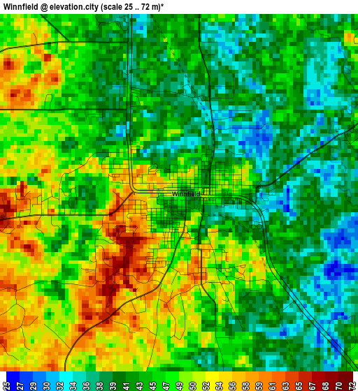
Below is the Elevation map of Winnfield, which displays elevation range with different colors. Scale of the first map is from 25 to 72 m (82 to 236 ft) with average elevation of 45.4 meters (=149 ft) [note 1]
These maps also provides idea of topography and contour of this city, they are displayed at different zoom levels. More info about maps, scale and edge coordinates you can find below images.
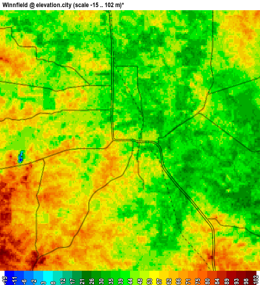
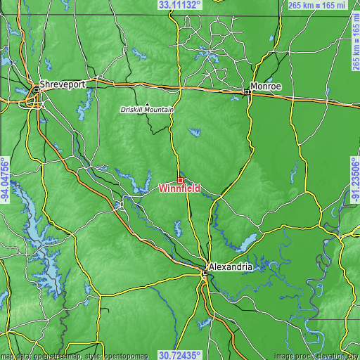
| \ | Map #1 | Map #2 | Topo.Map |
| Scale [m] | 25..72 m | -15..102 m | × |
| Scale [ft] | 82..236 ft | -49..335 ft | × |
| Average | 45.4 m = 149 ft | 48.7 m = 160 ft | × |
| Width | 8.29 km = 5.2 mi | 16.59 km = 10.3 mi | 265.4 km = 164.9 mi |
| Height | 8.29 km = 5.2 mi | 16.59 km = 10.3 mi | 265.4 km = 164.9 mi |
| ↑Max Latitude | 31.96287° | 32.000146° | 33.11132° |
| Latitude at center | 31.92558° | 31.92558° | 31.92558° |
| ↓Min Latitude | 31.888274° | 31.850954° | 30.72435° |
| ← Min Longitude | -92.685255° | -92.729201° | -94.04756° |
| Longitude center | -92.64131° | -92.64131° | -92.64131° |
| →Max Longitude | -92.597365° | -92.553419° | -91.23506° |
Nearby cities:
Cities around Winnfield sort by population:
• Natchitoches elevation 42 m
45.9 km,  246°
246°
• Jonesboro 72 m
35.8 km,  348°
348°
• Jena 54 m
55 km,  119°
119°
• Colfax 29 m
45.6 km,  187°
187°
• Olla 49 m
37.7 km,  93°
93°
• Urania 31 m
33.3 km,  101°
101°
• Midway 69 m
53 km, 119°
• Vienna Bend 38 m
43.4 km,  240°
240°
• Banks Springs 65 m
54.6 km,  71°
71°
• Campti 48 m
45.2 km,  265°
265°
• Clarks 44 m
48.7 km,  76°
76°
• Columbia 24 m
56.7 km, 69°
Multilingual:
 En español:
Winnfield elevación 46 m.
 En France:
Winnfield élévation 46 m.
 Auf Deutsch:
Winnfield höhe über dem Meeresspiegel ist 46 m.

Sources and notes:
- [note 1] Map square and city borders are not equal. Map elevation data is calculated only from area inside that square.
- [src 1] Elevation data from geonames database provided with same terms of usage.
- [src 2] The elevation map of Winnfield is generated using elevation data from NASA's 3 arcsec (90m) resolution SRTM data.
- [src 3] Base (background) map © OpenStreetMap contributors tiles are generated by Geofabrik and OpenTopoMap.
Copyright & License:
This Winnfield Elevation Map is licensed under CC BY-SA. You may reuse any part from this page, if you give a proper credit by linking to this URL:
 More info on terms of use page.