Ville Platte elevation
Ville Platte (Louisiana, Evangeline Parish), United States elevation is 28 meters and Ville Platte elevation in feet is 92 ft above sea level [src 1]. Ville Platte is a seat of a second-order administrative division (feature code) with elevation that is 251 meters (823 ft) smaller than average city elevation in United States.
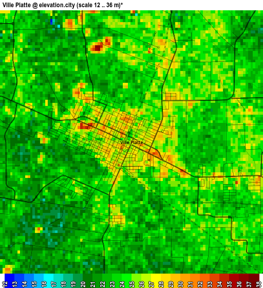
Below is the Elevation map of Ville Platte, which displays elevation range with different colors. Scale of the first map is from 12 to 36 m (39 to 118 ft) with average elevation of 23.3 meters (=76 ft) [note 1]
These maps also provides idea of topography and contour of this city, they are displayed at different zoom levels. More info about maps, scale and edge coordinates you can find below images.
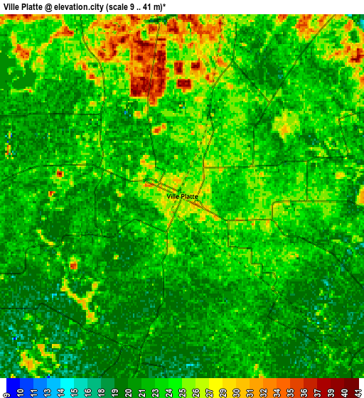
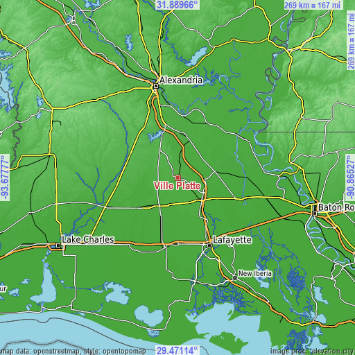
| \ | Map #1 | Map #2 | Topo.Map |
| Scale [m] | 12..36 m | 9..41 m | × |
| Scale [ft] | 39..118 ft | 30..135 ft | × |
| Average | 23.3 m = 76 ft | 23 m = 75 ft | × |
| Width | 8.4 km = 5.2 mi | 16.81 km = 10.4 mi | 268.9 km = 167.1 mi |
| Height | 8.4 km = 5.2 mi | 16.81 km = 10.4 mi | 268.9 km = 167.1 mi |
| ↑Max Latitude | 30.725754° | 30.763523° | 31.88966° |
| Latitude at center | 30.68797° | 30.68797° | 30.68797° |
| ↓Min Latitude | 30.650171° | 30.612358° | 29.47114° |
| ← Min Longitude | -92.315465° | -92.359411° | -93.67777° |
| Longitude center | -92.27152° | -92.27152° | -92.27152° |
| →Max Longitude | -92.227575° | -92.183629° | -90.86527° |
Nearby cities:
Cities around Ville Platte sort by population:
• Opelousas elevation 23 m
25 km,  133°
133°
• Eunice 17 m
25.7 km,  213°
213°
• Church Point 18 m
32.1 km,  170°
170°
• Bunkie 22 m
30.7 km,  16°
16°
• Mamou 26 m
15.4 km,  246°
246°
• Sunset 17 m
36.4 km,  147°
147°
• Port Barre 11 m
33.5 km,  115°
115°
• Cottonport 22 m
39 km,  32°
32°
• Basile 17 m
38.4 km,  234°
234°
• Pine Prairie 37 m
18.2 km,  305°
305°
• Lawtell 22 m
20.6 km,  156°
156°
• Leonville 12 m
37 km, 130°
Multilingual:
 En español:
Ville Platte elevación 28 m.
 En France:
Ville Platte élévation 28 m.
 Auf Deutsch:
Ville Platte höhe über dem Meeresspiegel ist 28 m.

Sources and notes:
- [note 1] Map square and city borders are not equal. Map elevation data is calculated only from area inside that square.
- [src 1] Elevation data from geonames database provided with same terms of usage.
- [src 2] The elevation map of Ville Platte is generated using elevation data from NASA's 3 arcsec (90m) resolution SRTM data.
- [src 3] Base (background) map © OpenStreetMap contributors tiles are generated by Geofabrik and OpenTopoMap.
Copyright & License:
This Ville Platte Elevation Map is licensed under CC BY-SA. You may reuse any part from this page, if you give a proper credit by linking to this URL:
 More info on terms of use page.