Rosepine elevation
Rosepine (Louisiana, Vernon Parish), United States elevation is 71 meters and Rosepine elevation in feet is 233 ft above sea level [src 1]. Rosepine is a populated place (feature code) with elevation that is 208 meters (682 ft) smaller than average city elevation in United States.
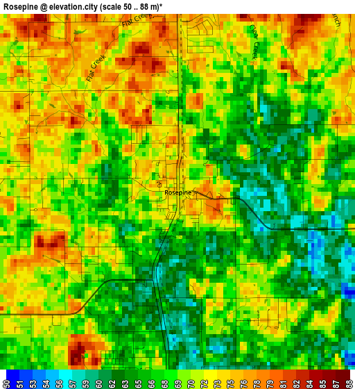
Below is the Elevation map of Rosepine, which displays elevation range with different colors. Scale of the first map is from 50 to 88 m (164 to 289 ft) with average elevation of 69.4 meters (=228 ft) [note 1]
These maps also provides idea of topography and contour of this city, they are displayed at different zoom levels. More info about maps, scale and edge coordinates you can find below images.
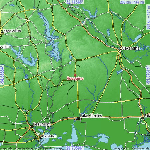
| \ | Map #1 | Topo.Map |
| Scale [m] | 50..88 m | × |
| Scale [ft] | 164..289 ft | × |
| Average | 69.4 m = 228 ft | × |
| Width | 8.38 km = 5.2 mi | 268.3 km = 166.7 mi |
| Height | 8.38 km = 5.2 mi | 268.3 km = 166.7 mi |
| ↑Max Latitude | 30.957603° | 32.11865° |
| Latitude at center | 30.91991° | 30.91991° |
| ↓Min Latitude | 30.882202° | 29.70596° |
| ← Min Longitude | -93.326335° | -94.68864° |
| Longitude center | -93.28239° | -93.28239° |
| →Max Longitude | -93.238445° | -91.87614° |
Nearby cities:
Cities around Rosepine sort by population:
• DeRidder elevation 67 m
8.2 km,  184°
184°
• Fort Polk South 92 m
15.9 km,  23°
23°
• Oakdale 38 m
60.5 km,  101°
101°
• Leesville 81 m
24.9 km,  4°
4°
• DeQuincy 28 m
54.2 km,  195°
195°
• Fort Polk North 118 m
22.6 km,  25°
25°
• New Llano 70 m
21.7 km, 2°
• Kinder 19 m
63.5 km,  139°
139°
• Newton 62 m
46 km,  260°
260°
• Kirbyville 40 m
65 km,  243°
243°
• Oberlin 24 m
59.8 km,  123°
123°
• Merryville 26 m
30.8 km,  233°
233°
Multilingual:
 En español:
Rosepine elevación 71 m.
 En France:
Rosepine élévation 71 m.


Sources and notes:
- [note 1] Map square and city borders are not equal. Map elevation data is calculated only from area inside that square.
- [src 1] Elevation data from geonames database provided with same terms of usage.
- [src 2] The elevation map of Rosepine is generated using elevation data from NASA's 3 arcsec (90m) resolution SRTM data.
- [src 3] Base (background) map © OpenStreetMap contributors tiles are generated by Geofabrik and OpenTopoMap.
Copyright & License:
This Rosepine Elevation Map is licensed under CC BY-SA. You may reuse any part from this page, if you give a proper credit by linking to this URL:
 More info on terms of use page.