Prien elevation
Prien (Louisiana, Calcasieu Parish), United States elevation is 21 meters and Prien elevation in feet is 69 ft above sea level [src 1]. Prien is a populated place (feature code) with elevation that is 258 meters (846 ft) smaller than average city elevation in United States.
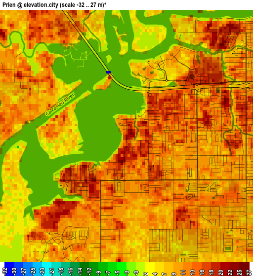
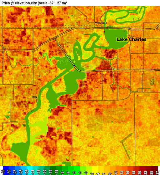
Below is the Elevation map of Prien, which displays elevation range with different colors. Scale of the first map is from -32 to 27 m (-105 to 89 ft) with average elevation of 8.5 meters (=28 ft) [note 1]
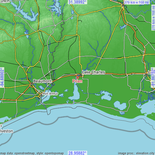
These maps also provides idea of topography and contour of this city, they are displayed at different zoom levels. More info about maps, scale and edge coordinates you can find below images.
| \ | Map #1 | Map #2 | Topo.Map |
| Scale [m] | -32..27 m | -32..27 m | × |
| Scale [ft] | -105..89 ft | -105..89 ft | × |
| Average | 8.5 m = 28 ft | 8.5 m = 28 ft | × |
| Width | 8.45 km = 5.3 mi | 16.9 km = 10.5 mi | 270.3 km = 168 mi |
| Height | 8.45 km = 5.3 mi | 16.9 km = 10.5 mi | 270.3 km = 168 mi |
| ↑Max Latitude | 30.21985° | 30.257816° | 31.38992° |
| Latitude at center | 30.18187° | 30.18187° | 30.18187° |
| ↓Min Latitude | 30.143875° | 30.105865° | 28.95882° |
| ← Min Longitude | -93.317715° | -93.361661° | -94.68002° |
| Longitude center | -93.27377° | -93.27377° | -93.27377° |
| →Max Longitude | -93.229825° | -93.185879° | -91.86752° |
Nearby cities:
Cities around Prien sort by population:
• Lake Charles elevation 6 m
7.5 km,  62°
62°
• Sulphur 7 m
11.7 km,  301°
301°
• Orange 7 m
45.6 km,  257°
257°
• Moss Bluff 21 m
15.6 km,  30°
30°
• Carlyss 7 m
9.9 km, 261°
• Westlake 14 m
7.1 km,  18°
18°
• Vinton 8 m
29.6 km,  271°
271°
• Welsh 11 m
43.8 km,  82°
82°
• Iowa 14 m
25.7 km, 76°
• DeQuincy 28 m
33.6 km,  332°
332°
• Hackberry 9 m
21.7 km,  197°
197°
• Cameron 5 m
43 km,  186°
186°
Multilingual:
 En español:
Prien elevación 21 m.
 En France:
Prien élévation 21 m.


Sources and notes:
- [note 1] Map square and city borders are not equal. Map elevation data is calculated only from area inside that square.
- [src 1] Elevation data from geonames database provided with same terms of usage.
- [src 2] The elevation map of Prien is generated using elevation data from NASA's 3 arcsec (90m) resolution SRTM data.
- [src 3] Base (background) map © OpenStreetMap contributors tiles are generated by Geofabrik and OpenTopoMap.
Copyright & License:
This Prien Elevation Map is licensed under CC BY-SA. You may reuse any part from this page, if you give a proper credit by linking to this URL:
 More info on terms of use page.