Pineville elevation
Pineville (Louisiana, Rapides Parish), United States elevation is 39 meters and Pineville elevation in feet is 128 ft above sea level [src 1]. Pineville is a populated place (feature code) with elevation that is 240 meters (787 ft) smaller than average city elevation in United States.
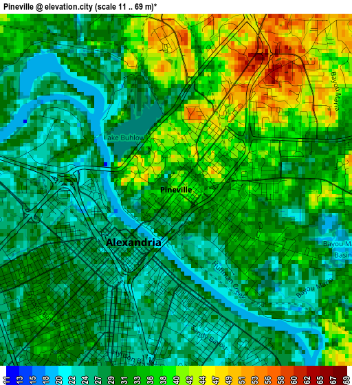
Below is the Elevation map of Pineville, which displays elevation range with different colors. Scale of the first map is from 11 to 69 m (36 to 226 ft) with average elevation of 32.2 meters (=106 ft) [note 1]
These maps also provides idea of topography and contour of this city, they are displayed at different zoom levels. More info about maps, scale and edge coordinates you can find below images.
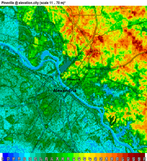
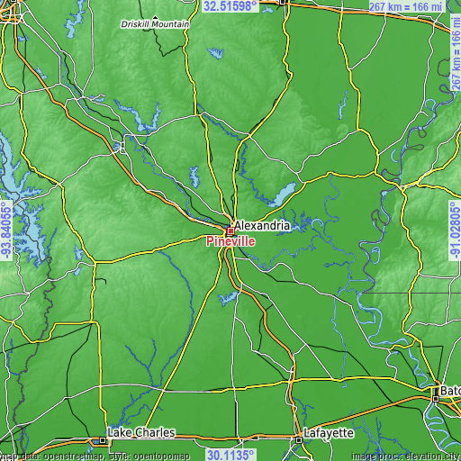
| \ | Map #1 | Map #2 | Topo.Map |
| Scale [m] | 11..69 m | 11..70 m | × |
| Scale [ft] | 36..226 ft | 36..230 ft | × |
| Average | 32.2 m = 106 ft | 33.9 m = 111 ft | × |
| Width | 8.35 km = 5.2 mi | 16.7 km = 10.4 mi | 267.1 km = 166 mi |
| Height | 8.35 km = 5.2 mi | 16.7 km = 10.4 mi | 267.1 km = 166 mi |
| ↑Max Latitude | 31.359933° | 31.397451° | 32.51598° |
| Latitude at center | 31.3224° | 31.3224° | 31.3224° |
| ↓Min Latitude | 31.284852° | 31.247289° | 30.1135° |
| ← Min Longitude | -92.478245° | -92.522191° | -93.84055° |
| Longitude center | -92.4343° | -92.4343° | -92.4343° |
| →Max Longitude | -92.390355° | -92.346409° | -91.02805° |
Nearby cities:
Cities around Pineville sort by population:
• Alexandria elevation 27 m
1.6 km,  219°
219°
• Marksville 28 m
41.1 km,  121°
121°
• Bunkie 22 m
47.5 km,  149°
149°
• Ball 54 m
10.6 km,  11°
11°
• Jena 54 m
49.2 km,  35°
35°
• Deville 27 m
25.8 km,  81°
81°
• Colfax 29 m
33.9 km,  310°
310°
• Mansura 30 m
47 km,  128°
128°
• Glenmora 42 m
41 km,  200°
200°
• Midway 69 m
49 km,  33°
33°
• Lecompte 25 m
25.5 km,  172°
172°
• Woodworth 29 m
20.4 km, 197°
Multilingual:
 En español:
Pineville elevación 39 m.
 En France:
Pineville élévation 39 m.
 Auf Deutsch:
Pineville höhe über dem Meeresspiegel ist 39 m.

Sources and notes:
- [note 1] Map square and city borders are not equal. Map elevation data is calculated only from area inside that square.
- [src 1] Elevation data from geonames database provided with same terms of usage.
- [src 2] The elevation map of Pineville is generated using elevation data from NASA's 3 arcsec (90m) resolution SRTM data.
- [src 3] Base (background) map © OpenStreetMap contributors tiles are generated by Geofabrik and OpenTopoMap.
Copyright & License:
This Pineville Elevation Map is licensed under CC BY-SA. You may reuse any part from this page, if you give a proper credit by linking to this URL:
 More info on terms of use page.