Amite elevation
Amite (Louisiana, Tangipahoa Parish), United States elevation is 38 meters and Amite elevation in feet is 125 ft above sea level [src 1]. Amite is a seat of a second-order administrative division (feature code) with elevation that is 241 meters (791 ft) smaller than average city elevation in United States.
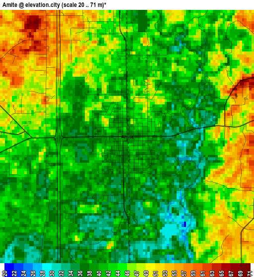
Below is the Elevation map of Amite, which displays elevation range with different colors. Scale of the first map is from 20 to 71 m (66 to 233 ft) with average elevation of 43.2 meters (=142 ft) [note 1]
These maps also provides idea of topography and contour of this city, they are displayed at different zoom levels. More info about maps, scale and edge coordinates you can find below images.
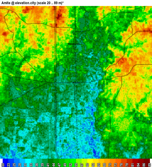
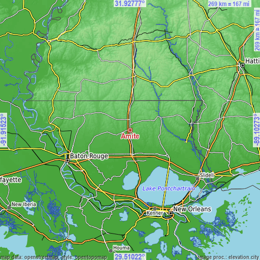
| \ | Map #1 | Map #2 | Topo.Map |
| Scale [m] | 20..71 m | 20..89 m | × |
| Scale [ft] | 66..233 ft | 66..292 ft | × |
| Average | 43.2 m = 142 ft | 48.4 m = 159 ft | × |
| Width | 8.4 km = 5.2 mi | 16.8 km = 10.4 mi | 268.8 km = 167 mi |
| Height | 8.4 km = 5.2 mi | 16.8 km = 10.4 mi | 268.8 km = 167 mi |
| ↑Max Latitude | 30.764339° | 30.802093° | 31.92777° |
| Latitude at center | 30.72657° | 30.72657° | 30.72657° |
| ↓Min Latitude | 30.688787° | 30.650988° | 29.51022° |
| ← Min Longitude | -90.552925° | -90.596871° | -91.91523° |
| Longitude center | -90.50898° | -90.50898° | -90.50898° |
| →Max Longitude | -90.465035° | -90.421089° | -89.10273° |
Nearby cities:
Cities around Amite sort by population:
• Hammond elevation 17 m
25.1 km,  169°
169°
• Ponchatoula 13 m
32.6 km, 168°
• Walker 17 m
42.9 km,  231°
231°
• Franklinton 48 m
36.4 km,  68°
68°
• Natalbany 21 m
20.2 km, 173°
• Kentwood 66 m
23.5 km,  0°
0°
• Livingston 18 m
33.8 km,  222°
222°
• Independence 28 m
10.1 km,  176°
176°
• Killian 10 m
41.6 km,  190°
190°
• Roseland 43 m
4.3 km,  356°
356°
• Albany 14 m
25.7 km,  195°
195°
• Greensburg 73 m
19.4 km,  306°
306°
Multilingual:
 En español:
Amite elevación 38 m.
 En France:
Amite élévation 38 m.


Sources and notes:
- [note 1] Map square and city borders are not equal. Map elevation data is calculated only from area inside that square.
- [src 1] Elevation data from geonames database provided with same terms of usage.
- [src 2] The elevation map of Amite is generated using elevation data from NASA's 3 arcsec (90m) resolution SRTM data.
- [src 3] Base (background) map © OpenStreetMap contributors tiles are generated by Geofabrik and OpenTopoMap.
Copyright & License:
This Amite Elevation Map is licensed under CC BY-SA. You may reuse any part from this page, if you give a proper credit by linking to this URL:
 More info on terms of use page.