Fort Thomas elevation
Fort Thomas (Kentucky, Campbell County), United States elevation is 264 meters and Fort Thomas elevation in feet is 866 ft above sea level [src 1]. Fort Thomas is a populated place (feature code) with elevation that is 15 meters (49 ft) smaller than average city elevation in United States.
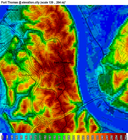
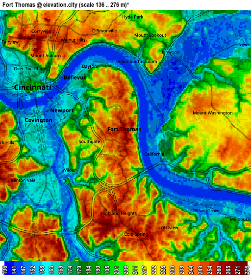
Below is the Elevation map of Fort Thomas, which displays elevation range with different colors. Scale of the first map is from 139 to 264 m (456 to 866 ft) with average elevation of 194.8 meters (=639 ft) [note 1]
These maps also provides idea of topography and contour of this city, they are displayed at different zoom levels. More info about maps, scale and edge coordinates you can find below images.
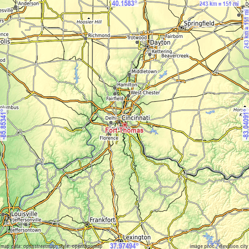
| \ | Map #1 | Map #2 | Topo.Map |
| Scale [m] | 139..264 m | 136..276 m | × |
| Scale [ft] | 456..866 ft | 446..906 ft | × |
| Average | 194.8 m = 639 ft | 197.1 m = 647 ft | × |
| Width | 7.59 km = 4.7 mi | 15.17 km = 9.4 mi | 242.8 km = 150.9 mi |
| Height | 7.59 km = 4.7 mi | 15.17 km = 9.4 mi | 242.8 km = 150.9 mi |
| ↑Max Latitude | 39.109167° | 39.143258° | 40.1583° |
| Latitude at center | 39.07506° | 39.07506° | 39.07506° |
| ↓Min Latitude | 39.040936° | 39.006796° | 37.97494° |
| ← Min Longitude | -84.491105° | -84.535051° | -85.85341° |
| Longitude center | -84.44716° | -84.44716° | -84.44716° |
| →Max Longitude | -84.403215° | -84.359269° | -83.04091° |
Nearby cities:
Cities around Fort Thomas sort by population:
• Covington elevation 157 m
5.4 km,  280°
280°
• Newport 158 m
4.6 km,  293°
293°
• Highland Heights 260 m
4.7 km,  185°
185°
• Cold Spring 262 m
6 km,  173°
173°
• Bellevue 169 m
4.4 km,  321°
321°
• Dayton 159 m
4.7 km,  332°
332°
• Turpin Hills 202 m
7 km,  56°
56°
• Southgate 213 m
2.2 km,  261°
261°
• Salem Heights 229 m
6 km,  93°
93°
• Fruit Hill 225 m
7.1 km, 89°
• Wilder 171 m
4 km,  238°
238°
• Silver Grove 154 m
6.7 km,  132°
132°
Multilingual:
 En español:
Fort Thomas elevación 264 m.
 En France:
Fort Thomas élévation 264 m.
 Auf Deutsch:
Fort Thomas höhe über dem Meeresspiegel ist 264 m.

Sources and notes:
- [note 1] Map square and city borders are not equal. Map elevation data is calculated only from area inside that square.
- [src 1] Elevation data from geonames database provided with same terms of usage.
- [src 2] The elevation map of Fort Thomas is generated using elevation data from NASA's 3 arcsec (90m) resolution SRTM data.
- [src 3] Base (background) map © OpenStreetMap contributors tiles are generated by Geofabrik and OpenTopoMap.
Copyright & License:
This Fort Thomas Elevation Map is licensed under CC BY-SA. You may reuse any part from this page, if you give a proper credit by linking to this URL:
 More info on terms of use page.