Clinton elevation
Clinton (Kentucky, Hickman County), United States elevation is 114 meters and Clinton elevation in feet is 374 ft above sea level [src 1]. Clinton is a seat of a second-order administrative division (feature code) with elevation that is 165 meters (541 ft) smaller than average city elevation in United States.
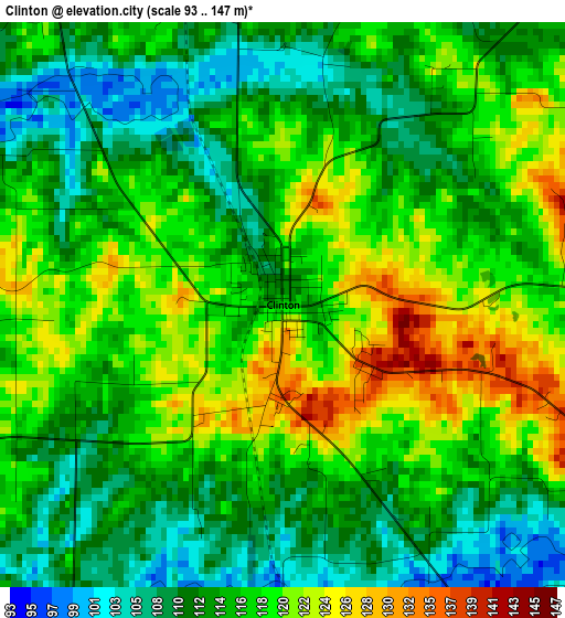
Below is the Elevation map of Clinton, which displays elevation range with different colors. Scale of the first map is from 93 to 147 m (305 to 482 ft) with average elevation of 115.6 meters (=379 ft) [note 1]
These maps also provides idea of topography and contour of this city, they are displayed at different zoom levels. More info about maps, scale and edge coordinates you can find below images.
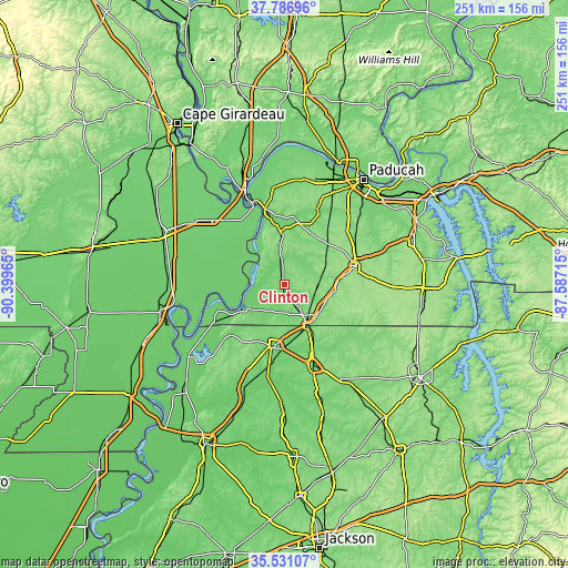
| \ | Map #1 | Topo.Map |
| Scale [m] | 93..147 m | × |
| Scale [ft] | 305..482 ft | × |
| Average | 115.6 m = 379 ft | × |
| Width | 7.84 km = 4.9 mi | 250.8 km = 155.8 mi |
| Height | 7.84 km = 4.9 mi | 250.8 km = 155.8 mi |
| ↑Max Latitude | 36.702521° | 37.78696° |
| Latitude at center | 36.66728° | 36.66728° |
| ↓Min Latitude | 36.632023° | 35.53107° |
| ← Min Longitude | -89.037345° | -90.39965° |
| Longitude center | -88.9934° | -88.9934° |
| →Max Longitude | -88.949455° | -87.58715° |
Nearby cities:
Cities around Clinton sort by population:
• Martin elevation 127 m
38.2 km,  160°
160°
• Union City 105 m
27.6 km,  191°
191°
• Mayfield 146 m
32.9 km,  75°
75°
• East Prairie 94 m
37.1 km,  289°
289°
• Cairo 94 m
41 km,  336°
336°
• South Fulton 111 m
21.3 km,  150°
150°
• Fulton 112 m
21 km, 149°
• Hickman 144 m
20.3 km,  238°
238°
• Englewood 135 m
36.4 km,  203°
203°
• Troy 115 m
39.6 km, 202°
• Bardwell 107 m
22.7 km,  356°
356°
• Wickliffe 108 m
34.2 km,  345°
345°
Multilingual:
 En español:
Clinton elevación 114 m.
 En France:
Clinton élévation 114 m.


Sources and notes:
- [note 1] Map square and city borders are not equal. Map elevation data is calculated only from area inside that square.
- [src 1] Elevation data from geonames database provided with same terms of usage.
- [src 2] The elevation map of Clinton is generated using elevation data from NASA's 3 arcsec (90m) resolution SRTM data.
- [src 3] Base (background) map © OpenStreetMap contributors tiles are generated by Geofabrik and OpenTopoMap.
Copyright & License:
This Clinton Elevation Map is licensed under CC BY-SA. You may reuse any part from this page, if you give a proper credit by linking to this URL:
 More info on terms of use page.