Hesston elevation
Hesston (Kansas, Harvey County), United States elevation is 457 meters and Hesston elevation in feet is 1499 ft above sea level [src 1]. Hesston is a populated place (feature code) with elevation that is 178 meters (584 ft) bigger than average city elevation in United States.
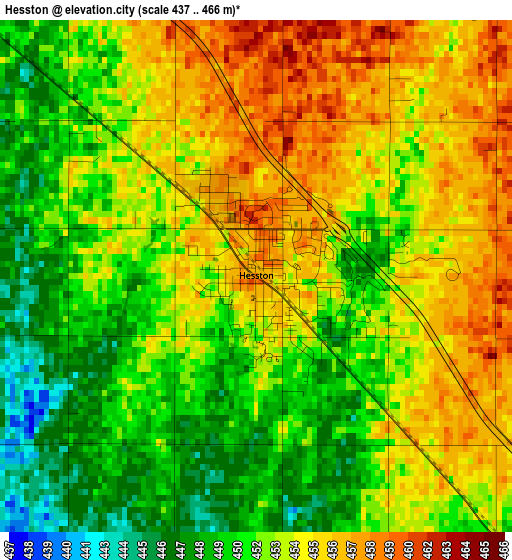
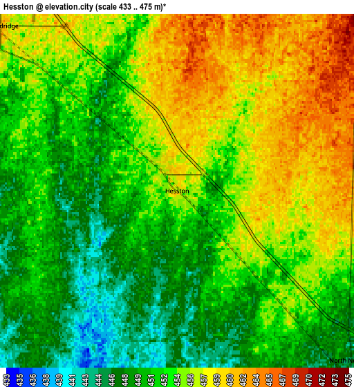
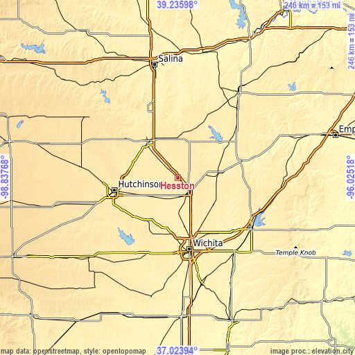
Below is the Elevation map of Hesston, which displays elevation range with different colors. Scale of the first map is from 437 to 466 m (1434 to 1529 ft) with average elevation of 452.7 meters (=1485 ft) [note 1]
These maps also provides idea of topography and contour of this city, they are displayed at different zoom levels. More info about maps, scale and edge coordinates you can find below images.
| \ | Map #1 | Map #2 | Topo.Map |
| Scale [m] | 437..466 m | 433..475 m | × |
| Scale [ft] | 1434..1529 ft | 1421..1558 ft | × |
| Average | 452.7 m = 1485 ft | 453.3 m = 1487 ft | × |
| Width | 7.69 km = 4.8 mi | 15.37 km = 9.6 mi | 246 km = 152.9 mi |
| Height | 7.69 km = 4.8 mi | 15.37 km = 9.6 mi | 246 km = 152.9 mi |
| ↑Max Latitude | 38.172896° | 38.207435° | 39.23598° |
| Latitude at center | 38.13834° | 38.13834° | 38.13834° |
| ↓Min Latitude | 38.103768° | 38.069179° | 37.02394° |
| ← Min Longitude | -97.475375° | -97.519321° | -98.83768° |
| Longitude center | -97.43143° | -97.43143° | -97.43143° |
| →Max Longitude | -97.387485° | -97.343539° | -96.02518° |
Nearby cities:
Cities around Hesston sort by population:
• Newton elevation 447 m
12.7 km,  143°
143°
• McPherson 462 m
32.9 km,  321°
321°
• Park City 421 m
38.9 km,  165°
165°
• Valley Center 418 m
34.1 km, 171°
• Hillsboro 444 m
30.9 km,  39°
39°
• Halstead 432 m
16.7 km,  203°
203°
• North Newton 444 m
10.5 km,  134°
134°
• Sedgwick 426 m
24.7 km,  178°
178°
• Moundridge 462 m
10.5 km,  313°
313°
• Inman 473 m
31.6 km,  289°
289°
• Buhler 459 m
29.6 km,  269°
269°
• Peabody 430 m
28.6 km,  83°
83°
Multilingual:
 En español:
Hesston elevación 457 m.
 En France:
Hesston élévation 457 m.


Sources and notes:
- [note 1] Map square and city borders are not equal. Map elevation data is calculated only from area inside that square.
- [src 1] Elevation data from geonames database provided with same terms of usage.
- [src 2] The elevation map of Hesston is generated using elevation data from NASA's 3 arcsec (90m) resolution SRTM data.
- [src 3] Base (background) map © OpenStreetMap contributors tiles are generated by Geofabrik and OpenTopoMap.
Copyright & License:
This Hesston Elevation Map is licensed under CC BY-SA. You may reuse any part from this page, if you give a proper credit by linking to this URL:
 More info on terms of use page.