Cottonwood Falls elevation
Cottonwood Falls (Kansas, Chase County), United States elevation is 373 meters and Cottonwood Falls elevation in feet is 1224 ft above sea level [src 1]. Cottonwood Falls is a seat of a second-order administrative division (feature code) with elevation that is 94 meters (308 ft) bigger than average city elevation in United States.
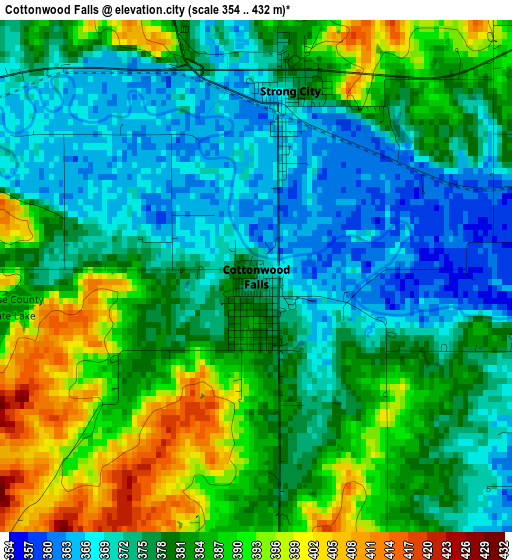
Below is the Elevation map of Cottonwood Falls, which displays elevation range with different colors. Scale of the first map is from 354 to 432 m (1161 to 1417 ft) with average elevation of 379.4 meters (=1245 ft) [note 1]
These maps also provides idea of topography and contour of this city, they are displayed at different zoom levels. More info about maps, scale and edge coordinates you can find below images.
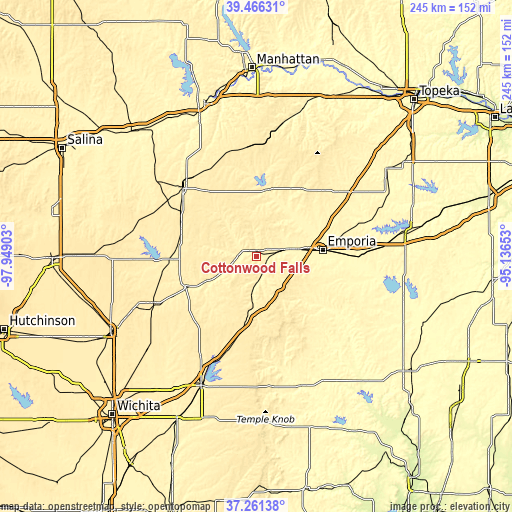
| \ | Map #1 | Topo.Map |
| Scale [m] | 354..432 m | × |
| Scale [ft] | 1161..1417 ft | × |
| Average | 379.4 m = 1245 ft | × |
| Width | 7.66 km = 4.8 mi | 245.2 km = 152.4 mi |
| Height | 7.66 km = 4.8 mi | 245.2 km = 152.4 mi |
| ↑Max Latitude | 38.406685° | 39.46631° |
| Latitude at center | 38.37224° | 38.37224° |
| ↓Min Latitude | 38.337779° | 37.26138° |
| ← Min Longitude | -96.586725° | -97.94903° |
| Longitude center | -96.54278° | -96.54278° |
| →Max Longitude | -96.498835° | -95.13653° |
Nearby cities:
Cities around Cottonwood Falls sort by population:
• Emporia elevation 353 m
31.7 km,  83°
83°
• El Dorado 418 m
67.7 km,  204°
204°
• Hillsboro 444 m
57.7 km,  267°
267°
• Osage City 332 m
68.8 km,  64°
64°
• Burlington 318 m
72.6 km,  105°
105°
• Eureka 333 m
64.9 km,  159°
159°
• Herington 419 m
48.1 km,  313°
313°
• Council Grove 381 m
32.4 km,  7°
7°
• Marion 405 m
41.5 km, 266°
• Towanda 400 m
75.4 km,  212°
212°
• Peabody 430 m
54.1 km,  245°
245°
• Alma 340 m
75 km,  17°
17°
Multilingual:
 En español:
Cottonwood Falls elevación 373 m.
 En France:
Cottonwood Falls élévation 373 m.
 Auf Deutsch:
Cottonwood Falls höhe über dem Meeresspiegel ist 373 m.

Sources and notes:
- [note 1] Map square and city borders are not equal. Map elevation data is calculated only from area inside that square.
- [src 1] Elevation data from geonames database provided with same terms of usage.
- [src 2] The elevation map of Cottonwood Falls is generated using elevation data from NASA's 3 arcsec (90m) resolution SRTM data.
- [src 3] Base (background) map © OpenStreetMap contributors tiles are generated by Geofabrik and OpenTopoMap.
Copyright & License:
This Cottonwood Falls Elevation Map is licensed under CC BY-SA. You may reuse any part from this page, if you give a proper credit by linking to this URL:
 More info on terms of use page.