Dale elevation
Dale (Indiana, Spencer County), United States elevation is 143 meters and Dale elevation in feet is 469 ft above sea level [src 1]. Dale is a populated place (feature code) with elevation that is 136 meters (446 ft) smaller than average city elevation in United States.
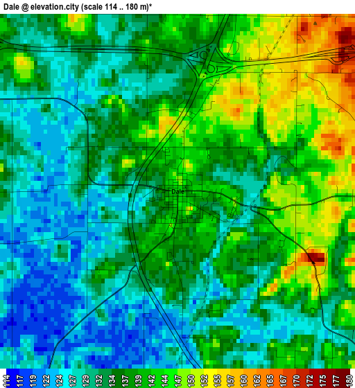
Below is the Elevation map of Dale, which displays elevation range with different colors. Scale of the first map is from 114 to 180 m (374 to 591 ft) with average elevation of 136 meters (=446 ft) [note 1]
These maps also provides idea of topography and contour of this city, they are displayed at different zoom levels. More info about maps, scale and edge coordinates you can find below images.
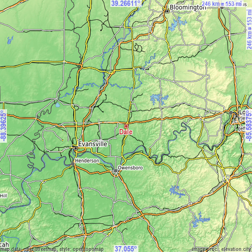
| \ | Map #1 | Topo.Map |
| Scale [m] | 114..180 m | × |
| Scale [ft] | 374..591 ft | × |
| Average | 136 m = 446 ft | × |
| Width | 7.68 km = 4.8 mi | 245.9 km = 152.8 mi |
| Height | 7.68 km = 4.8 mi | 245.8 km = 152.7 mi |
| ↑Max Latitude | 38.203481° | 39.26611° |
| Latitude at center | 38.16894° | 38.16894° |
| ↓Min Latitude | 38.134382° | 37.055° |
| ← Min Longitude | -87.033945° | -88.39625° |
| Longitude center | -86.99° | -86.99° |
| →Max Longitude | -86.946055° | -85.58375° |
Nearby cities:
Cities around Dale sort by population:
• Jasper elevation 146 m
25.3 km,  11°
11°
• Tell City 126 m
31 km,  141°
141°
• Boonville 131 m
28.2 km,  241°
241°
• Huntingburg 150 m
14.8 km, 11°
• Chandler 126 m
36 km,  246°
246°
• Santa Claus 145 m
8.6 km,  129°
129°
• Oakland City 138 m
36.3 km,  301°
301°
• Rockport 133 m
32.2 km,  189°
189°
• Ferdinand 162 m
12.7 km,  61°
61°
• Lewisport 120 m
26.9 km,  163°
163°
• Cannelton 123 m
35.8 km, 143°
• Hawesville 163 m
36.3 km,  145°
145°
Multilingual:
 En español:
Dale elevación 143 m.
 En France:
Dale élévation 143 m.


Sources and notes:
- [note 1] Map square and city borders are not equal. Map elevation data is calculated only from area inside that square.
- [src 1] Elevation data from geonames database provided with same terms of usage.
- [src 2] The elevation map of Dale is generated using elevation data from NASA's 3 arcsec (90m) resolution SRTM data.
- [src 3] Base (background) map © OpenStreetMap contributors tiles are generated by Geofabrik and OpenTopoMap.
Copyright & License:
This Dale Elevation Map is licensed under CC BY-SA. You may reuse any part from this page, if you give a proper credit by linking to this URL:
 More info on terms of use page.