Austin elevation
Austin (Indiana, Scott County), United States elevation is 172 meters and Austin elevation in feet is 564 ft above sea level [src 1]. Austin is a populated place (feature code) with elevation that is 107 meters (351 ft) smaller than average city elevation in United States.
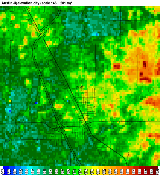
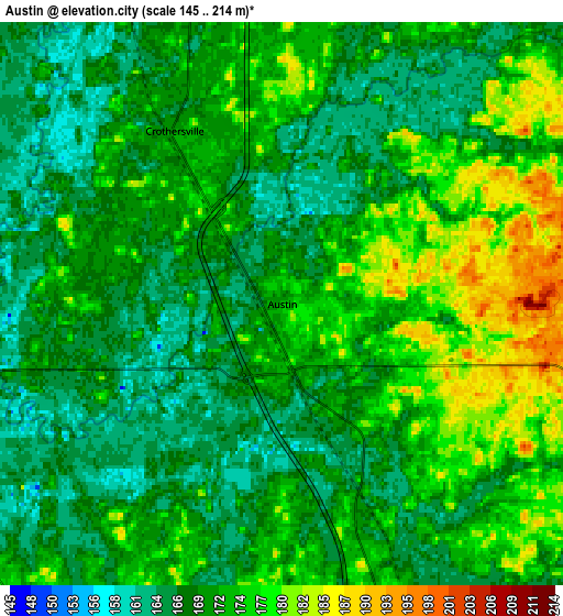
Below is the Elevation map of Austin, which displays elevation range with different colors. Scale of the first map is from 146 to 201 m (479 to 659 ft) with average elevation of 169.4 meters (=556 ft) [note 1]
These maps also provides idea of topography and contour of this city, they are displayed at different zoom levels. More info about maps, scale and edge coordinates you can find below images.
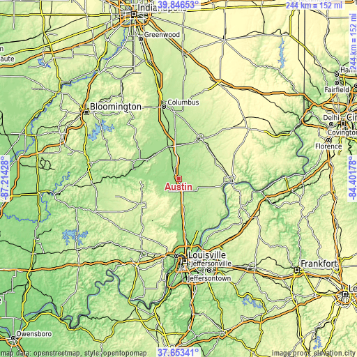
| \ | Map #1 | Map #2 | Topo.Map |
| Scale [m] | 146..201 m | 145..214 m | × |
| Scale [ft] | 479..659 ft | 476..702 ft | × |
| Average | 169.4 m = 556 ft | 171 m = 561 ft | × |
| Width | 7.62 km = 4.7 mi | 15.24 km = 9.5 mi | 243.9 km = 151.6 mi |
| Height | 7.62 km = 4.7 mi | 15.24 km = 9.5 mi | 243.8 km = 151.5 mi |
| ↑Max Latitude | 38.79265° | 38.826894° | 39.84653° |
| Latitude at center | 38.75839° | 38.75839° | 38.75839° |
| ↓Min Latitude | 38.724114° | 38.689821° | 37.65341° |
| ← Min Longitude | -85.851975° | -85.895921° | -87.21428° |
| Longitude center | -85.80803° | -85.80803° | -85.80803° |
| →Max Longitude | -85.764085° | -85.720139° | -84.40178° |
Nearby cities:
Cities around Austin sort by population:
• Seymour elevation 185 m
23.4 km,  342°
342°
• North Madison 275 m
35.7 km,  88°
88°
• Charlestown 181 m
36 km,  160°
160°
• Scottsburg 173 m
8.7 km, 157°
• North Vernon 220 m
31.8 km,  30°
30°
• Salem 231 m
30.6 km,  236°
236°
• Country Squire Lakes 214 m
32.2 km,  17°
17°
• Hanover 238 m
29.4 km,  99°
99°
• Brownstown 191 m
24.3 km,  303°
303°
• Henryville 157 m
24.3 km,  171°
171°
• Crothersville 171 m
5.5 km,  328°
328°
• New Pekin 219 m
33.5 km,  212°
212°
Multilingual:
 En español:
Austin elevación 172 m.
 En France:
Austin élévation 172 m.


Sources and notes:
- [note 1] Map square and city borders are not equal. Map elevation data is calculated only from area inside that square.
- [src 1] Elevation data from geonames database provided with same terms of usage.
- [src 2] The elevation map of Austin is generated using elevation data from NASA's 3 arcsec (90m) resolution SRTM data.
- [src 3] Base (background) map © OpenStreetMap contributors tiles are generated by Geofabrik and OpenTopoMap.
Copyright & License:
This Austin Elevation Map is licensed under CC BY-SA. You may reuse any part from this page, if you give a proper credit by linking to this URL:
 More info on terms of use page.