Troy elevation
Troy (Illinois, Madison County), United States elevation is 170 meters and Troy elevation in feet is 558 ft above sea level [src 1]. Troy is a populated place (feature code) with elevation that is 109 meters (358 ft) smaller than average city elevation in United States.
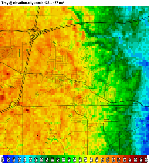
Below is the Elevation map of Troy, which displays elevation range with different colors. Scale of the first map is from 136 to 187 m (446 to 614 ft) with average elevation of 163.5 meters (=536 ft) [note 1]
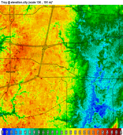
These maps also provides idea of topography and contour of this city, they are displayed at different zoom levels. More info about maps, scale and edge coordinates you can find below images.
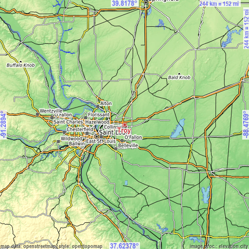
| \ | Map #1 | Map #2 | Topo.Map |
| Scale [m] | 136..187 m | 130..191 m | × |
| Scale [ft] | 446..614 ft | 427..627 ft | × |
| Average | 163.5 m = 536 ft | 160.2 m = 526 ft | × |
| Width | 7.62 km = 4.7 mi | 15.25 km = 9.5 mi | 244 km = 151.6 mi |
| Height | 7.62 km = 4.7 mi | 15.25 km = 9.5 mi | 243.9 km = 151.6 mi |
| ↑Max Latitude | 38.763484° | 38.797742° | 39.8178° |
| Latitude at center | 38.72921° | 38.72921° | 38.72921° |
| ↓Min Latitude | 38.69492° | 38.660613° | 37.62378° |
| ← Min Longitude | -89.927095° | -89.971041° | -91.2894° |
| Longitude center | -89.88315° | -89.88315° | -89.88315° |
| →Max Longitude | -89.839205° | -89.795259° | -88.4769° |
Nearby cities:
Cities around Troy sort by population:
• O'Fallon elevation 168 m
15.4 km,  189°
189°
• Edwardsville 169 m
11 km,  326°
326°
• Collinsville 175 m
11 km,  233°
233°
• Fairview Heights 177 m
18.2 km,  210°
210°
• Glen Carbon 144 m
8.9 km,  283°
283°
• Highland 162 m
18.4 km,  86°
86°
• Maryville 175 m
6.3 km,  264°
264°
• Pontoon Beach 131 m
17.1 km,  270°
270°
• Lebanon 159 m
15.4 km,  154°
154°
• Caseyville 141 m
16.1 km, 230°
• Mitchell 132 m
17.9 km, 281°
• Saint Jacob 158 m
10.1 km,  99°
99°
Multilingual:
 En español:
Troy elevación 170 m.
 En France:
Troy élévation 170 m.


Sources and notes:
- [note 1] Map square and city borders are not equal. Map elevation data is calculated only from area inside that square.
- [src 1] Elevation data from geonames database provided with same terms of usage.
- [src 2] The elevation map of Troy is generated using elevation data from NASA's 3 arcsec (90m) resolution SRTM data.
- [src 3] Base (background) map © OpenStreetMap contributors tiles are generated by Geofabrik and OpenTopoMap.
Copyright & License:
This Troy Elevation Map is licensed under CC BY-SA. You may reuse any part from this page, if you give a proper credit by linking to this URL:
 More info on terms of use page.