Bethalto elevation
Bethalto (Illinois, Madison County), United States elevation is 160 meters and Bethalto elevation in feet is 525 ft above sea level [src 1]. Bethalto is a populated place (feature code) with elevation that is 119 meters (390 ft) smaller than average city elevation in United States.
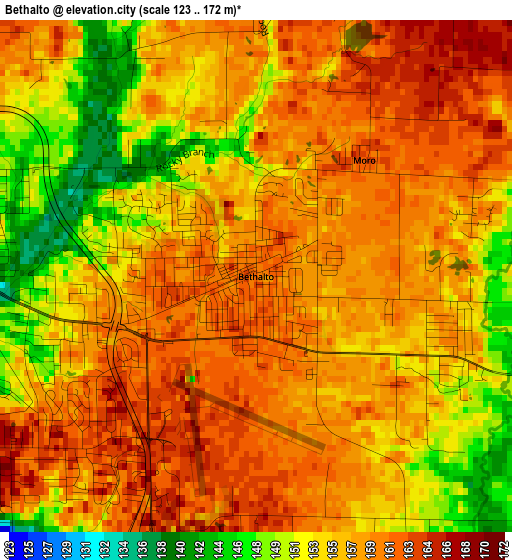
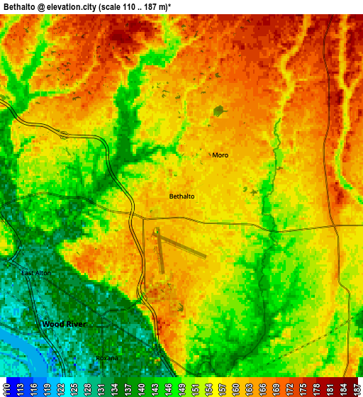
Below is the Elevation map of Bethalto, which displays elevation range with different colors. Scale of the first map is from 123 to 172 m (404 to 564 ft) with average elevation of 156.5 meters (=513 ft) [note 1]
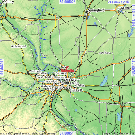
These maps also provides idea of topography and contour of this city, they are displayed at different zoom levels. More info about maps, scale and edge coordinates you can find below images.
| \ | Map #1 | Map #2 | Topo.Map |
| Scale [m] | 123..172 m | 110..187 m | × |
| Scale [ft] | 404..564 ft | 361..614 ft | × |
| Average | 156.5 m = 513 ft | 154.7 m = 508 ft | × |
| Width | 7.6 km = 4.7 mi | 15.21 km = 9.5 mi | 243.3 km = 151.2 mi |
| Height | 7.6 km = 4.7 mi | 15.21 km = 9.5 mi | 243.3 km = 151.2 mi |
| ↑Max Latitude | 38.943397° | 38.977568° | 39.99502° |
| Latitude at center | 38.90921° | 38.90921° | 38.90921° |
| ↓Min Latitude | 38.875006° | 38.840786° | 37.80654° |
| ← Min Longitude | -90.084605° | -90.128551° | -91.44691° |
| Longitude center | -90.04066° | -90.04066° | -90.04066° |
| →Max Longitude | -89.996715° | -89.952769° | -88.63441° |
Nearby cities:
Cities around Bethalto sort by population:
• Upper Alton elevation 169 m
9.5 km,  271°
271°
• Alton 152 m
12.6 km,  260°
260°
• Edwardsville 169 m
13.3 km,  145°
145°
• Godfrey 188 m
13.7 km,  292°
292°
• Wood River 132 m
7.3 km,  222°
222°
• East Alton 131 m
6.9 km,  242°
242°
• Rosewood Heights 168 m
4.5 km, 238°
• Holiday Shores 157 m
8.8 km,  80°
80°
• South Roxana 137 m
9.1 km,  192°
192°
• Bunker Hill 202 m
16.7 km,  27°
27°
• Roxana 129 m
7.4 km,  204°
204°
• Hartford 129 m
9.7 km,  209°
209°
Multilingual:
 En español:
Bethalto elevación 160 m.
 En France:
Bethalto élévation 160 m.
 Auf Deutsch:
Bethalto höhe über dem Meeresspiegel ist 160 m.

Sources and notes:
- [note 1] Map square and city borders are not equal. Map elevation data is calculated only from area inside that square.
- [src 1] Elevation data from geonames database provided with same terms of usage.
- [src 2] The elevation map of Bethalto is generated using elevation data from NASA's 3 arcsec (90m) resolution SRTM data.
- [src 3] Base (background) map © OpenStreetMap contributors tiles are generated by Geofabrik and OpenTopoMap.
Copyright & License:
This Bethalto Elevation Map is licensed under CC BY-SA. You may reuse any part from this page, if you give a proper credit by linking to this URL:
 More info on terms of use page.