Mountain City elevation
Mountain City (Georgia, Rabun County), United States elevation is 661 meters and Mountain City elevation in feet is 2169 ft above sea level [src 1]. Mountain City is a populated place (feature code) with elevation that is 382 meters (1253 ft) bigger than average city elevation in United States.
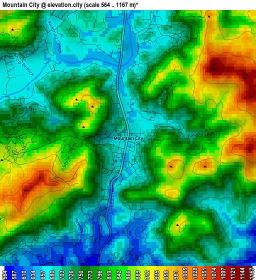
Below is the Elevation map of Mountain City, which displays elevation range with different colors. Scale of the first map is from 564 to 1167 m (1850 to 3829 ft) with average elevation of 777.4 meters (=2551 ft) [note 1]
These maps also provides idea of topography and contour of this city, they are displayed at different zoom levels. More info about maps, scale and edge coordinates you can find below images.
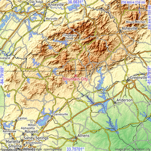
| \ | Map #1 | Topo.Map |
| Scale [m] | 564..1167 m | × |
| Scale [ft] | 1850..3829 ft | × |
| Average | 777.4 m = 2551 ft | × |
| Width | 8.01 km = 5 mi | 256.4 km = 159.3 mi |
| Height | 8.01 km = 5 mi | 256.4 km = 159.3 mi |
| ↑Max Latitude | 34.954176° | 36.0631° |
| Latitude at center | 34.91815° | 34.91815° |
| ↓Min Latitude | 34.882108° | 33.75701° |
| ← Min Longitude | -83.429385° | -84.79169° |
| Longitude center | -83.38544° | -83.38544° |
| →Max Longitude | -83.341495° | -81.97919° |
Nearby cities:
Cities around Mountain City sort by population:
• Toccoa elevation 306 m
38.2 km,  172°
172°
• Walhalla 312 m
33.9 km,  120°
120°
• Cornelia 464 m
47 km,  195°
195°
• Franklin 651 m
29.4 km,  0°
0°
• Westminster 283 m
38.6 km,  136°
136°
• Clayton 593 m
4.7 km, 197°
• Demorest 415 m
41.9 km, 200°
• Clarkesville 422 m
36.3 km, 200°
• Young Harris 585 m
42.1 km,  272°
272°
• Mount Airy 474 m
45.6 km,  193°
193°
• Hiawassee 600 m
34.1 km,  275°
275°
• Hayesville 575 m
41.9 km,  289°
289°
Multilingual:
 En español:
Mountain City elevación 661 m.
 En France:
Mountain City élévation 661 m.
 Auf Deutsch:
Mountain City höhe über dem Meeresspiegel ist 661 m.

Sources and notes:
- [note 1] Map square and city borders are not equal. Map elevation data is calculated only from area inside that square.
- [src 1] Elevation data from geonames database provided with same terms of usage.
- [src 2] The elevation map of Mountain City is generated using elevation data from NASA's 3 arcsec (90m) resolution SRTM data.
- [src 3] Base (background) map © OpenStreetMap contributors tiles are generated by Geofabrik and OpenTopoMap.
Copyright & License:
This Mountain City Elevation Map is licensed under CC BY-SA. You may reuse any part from this page, if you give a proper credit by linking to this URL:
 More info on terms of use page.