Metter elevation
Metter (Georgia, Candler County), United States elevation is 69 meters and Metter elevation in feet is 226 ft above sea level [src 1]. Metter is a seat of a second-order administrative division (feature code) with elevation that is 210 meters (689 ft) smaller than average city elevation in United States.
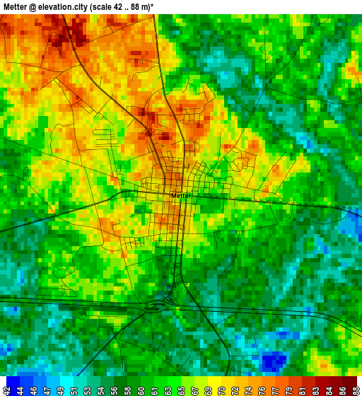
Below is the Elevation map of Metter, which displays elevation range with different colors. Scale of the first map is from 42 to 88 m (138 to 289 ft) with average elevation of 62.7 meters (=206 ft) [note 1]
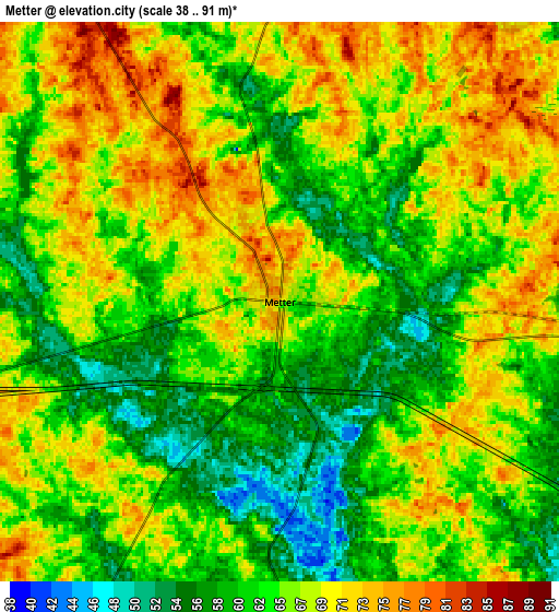
These maps also provides idea of topography and contour of this city, they are displayed at different zoom levels. More info about maps, scale and edge coordinates you can find below images.
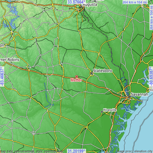
| \ | Map #1 | Map #2 | Topo.Map |
| Scale [m] | 42..88 m | 38..91 m | × |
| Scale [ft] | 138..289 ft | 125..299 ft | × |
| Average | 62.7 m = 206 ft | 65 m = 213 ft | × |
| Width | 8.25 km = 5.1 mi | 16.5 km = 10.3 mi | 264 km = 164 mi |
| Height | 8.25 km = 5.1 mi | 16.5 km = 10.3 mi | 264 km = 164 mi |
| ↑Max Latitude | 32.434218° | 32.4713° | 33.57664° |
| Latitude at center | 32.39712° | 32.39712° | 32.39712° |
| ↓Min Latitude | 32.360007° | 32.322879° | 31.20199° |
| ← Min Longitude | -82.104065° | -82.148011° | -83.46637° |
| Longitude center | -82.06012° | -82.06012° | -82.06012° |
| →Max Longitude | -82.016175° | -81.972229° | -80.65387° |
Nearby cities:
Cities around Metter sort by population:
• Statesboro elevation 82 m
26.6 km,  77°
77°
• Vidalia 94 m
38.7 km,  239°
239°
• Swainsboro 101 m
34 km,  310°
310°
• Glennville 57 m
52.7 km,  166°
166°
• Lyons 74 m
32.6 km,  228°
228°
• Soperton 93 m
50 km,  267°
267°
• Millen 56 m
46.4 km,  12°
12°
• Reidsville 68 m
34.9 km,  188°
188°
• Pembroke 34 m
50.3 km,  125°
125°
• Claxton 59 m
30 km,  150°
150°
• Twin City 98 m
22.5 km,  336°
336°
• Brooklet 50 m
37.3 km,  92°
92°
Multilingual:
 En español:
Metter elevación 69 m.
 En France:
Metter élévation 69 m.


Sources and notes:
- [note 1] Map square and city borders are not equal. Map elevation data is calculated only from area inside that square.
- [src 1] Elevation data from geonames database provided with same terms of usage.
- [src 2] The elevation map of Metter is generated using elevation data from NASA's 3 arcsec (90m) resolution SRTM data.
- [src 3] Base (background) map © OpenStreetMap contributors tiles are generated by Geofabrik and OpenTopoMap.
Copyright & License:
This Metter Elevation Map is licensed under CC BY-SA. You may reuse any part from this page, if you give a proper credit by linking to this URL:
 More info on terms of use page.