Gumlog elevation
Gumlog (Georgia, Franklin County), United States elevation is 234 meters and Gumlog elevation in feet is 768 ft above sea level [src 1]. Gumlog is a populated place (feature code) with elevation that is 45 meters (148 ft) smaller than average city elevation in United States.
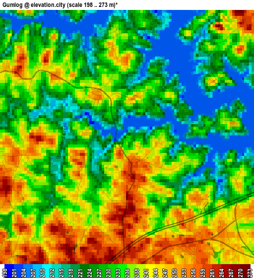
Below is the Elevation map of Gumlog, which displays elevation range with different colors. Scale of the first map is from 198 to 273 m (650 to 896 ft) with average elevation of 232.5 meters (=763 ft) [note 1]
These maps also provides idea of topography and contour of this city, they are displayed at different zoom levels. More info about maps, scale and edge coordinates you can find below images.
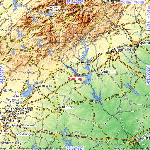
| \ | Map #1 | Topo.Map |
| Scale [m] | 198..273 m | × |
| Scale [ft] | 650..896 ft | × |
| Average | 232.5 m = 763 ft | × |
| Width | 8.05 km = 5 mi | 257.7 km = 160.1 mi |
| Height | 8.05 km = 5 mi | 257.7 km = 160.1 mi |
| ↑Max Latitude | 34.527982° | 35.64272° |
| Latitude at center | 34.49177° | 34.49177° |
| ↓Min Latitude | 34.455542° | 33.32472° |
| ← Min Longitude | -83.140485° | -84.50279° |
| Longitude center | -83.09654° | -83.09654° |
| →Max Longitude | -83.052595° | -81.69029° |
Nearby cities:
Cities around Gumlog sort by population:
• Clemson elevation 222 m
31.9 km,  48°
48°
• Toccoa 306 m
23.6 km,  293°
293°
• Seneca 292 m
25.2 km,  31°
31°
• Hartwell 252 m
21.6 km,  135°
135°
• Walhalla 312 m
30.5 km,  5°
5°
• Reed Creek 252 m
16.5 km,  107°
107°
• Royston 277 m
22.8 km,  183°
183°
• Westminster 283 m
19.2 km,  0°
0°
• Lavonia 260 m
6.3 km,  188°
188°
• Utica 271 m
25.6 km,  36°
36°
• Franklin Springs 254 m
23.4 km, 190°
• Carnesville 223 m
18.6 km,  223°
223°
Multilingual:
 En español:
Gumlog elevación 234 m.
 En France:
Gumlog élévation 234 m.


Sources and notes:
- [note 1] Map square and city borders are not equal. Map elevation data is calculated only from area inside that square.
- [src 1] Elevation data from geonames database provided with same terms of usage.
- [src 2] The elevation map of Gumlog is generated using elevation data from NASA's 3 arcsec (90m) resolution SRTM data.
- [src 3] Base (background) map © OpenStreetMap contributors tiles are generated by Geofabrik and OpenTopoMap.
Copyright & License:
This Gumlog Elevation Map is licensed under CC BY-SA. You may reuse any part from this page, if you give a proper credit by linking to this URL:
 More info on terms of use page.