Elberton elevation
Elberton (Georgia, Elbert County), United States elevation is 213 meters and Elberton elevation in feet is 699 ft above sea level [src 1]. Elberton is a seat of a second-order administrative division (feature code) with elevation that is 66 meters (217 ft) smaller than average city elevation in United States.
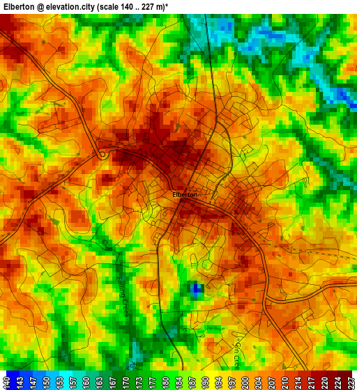
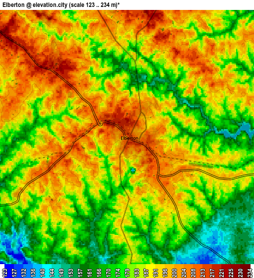
Below is the Elevation map of Elberton, which displays elevation range with different colors. Scale of the first map is from 140 to 227 m (459 to 745 ft) with average elevation of 194.1 meters (=637 ft) [note 1]
These maps also provides idea of topography and contour of this city, they are displayed at different zoom levels. More info about maps, scale and edge coordinates you can find below images.
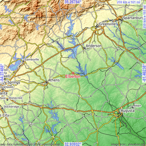
| \ | Map #1 | Map #2 | Topo.Map |
| Scale [m] | 140..227 m | 123..234 m | × |
| Scale [ft] | 459..745 ft | 404..768 ft | × |
| Average | 194.1 m = 637 ft | 185.6 m = 609 ft | × |
| Width | 8.09 km = 5 mi | 16.18 km = 10.1 mi | 258.9 km = 160.9 mi |
| Height | 8.09 km = 5 mi | 16.18 km = 10.1 mi | 258.9 km = 160.9 mi |
| ↑Max Latitude | 34.147967° | 34.184327° | 35.26784° |
| Latitude at center | 34.11159° | 34.11159° | 34.11159° |
| ↓Min Latitude | 34.075198° | 34.03879° | 32.93932° |
| ← Min Longitude | -82.912575° | -82.956521° | -84.27488° |
| Longitude center | -82.86863° | -82.86863° | -82.86863° |
| →Max Longitude | -82.824685° | -82.780739° | -81.46238° |
Nearby cities:
Cities around Elberton sort by population:
• Hartwell elevation 252 m
27.5 km,  347°
347°
• Reed Creek 252 m
37.5 km, 352°
• Royston 277 m
29.6 km,  311°
311°
• Lavonia 260 m
42.2 km,  328°
328°
• Calhoun Falls 161 m
25.2 km,  94°
94°
• Iva 221 m
28.7 km,  41°
41°
• Winterville 252 m
41 km,  246°
246°
• Franklin Springs 254 m
31.8 km, 307°
• Comer 213 m
24.2 km,  257°
257°
• Lake Secession 175 m
31.7 km,  52°
52°
• Danielsville 226 m
32.5 km,  272°
272°
• Lexington 213 m
35 km,  219°
219°
Multilingual:
 En español:
Elberton elevación 213 m.
 En France:
Elberton élévation 213 m.
 Auf Deutsch:
Elberton höhe über dem Meeresspiegel ist 213 m.

Sources and notes:
- [note 1] Map square and city borders are not equal. Map elevation data is calculated only from area inside that square.
- [src 1] Elevation data from geonames database provided with same terms of usage.
- [src 2] The elevation map of Elberton is generated using elevation data from NASA's 3 arcsec (90m) resolution SRTM data.
- [src 3] Base (background) map © OpenStreetMap contributors tiles are generated by Geofabrik and OpenTopoMap.
Copyright & License:
This Elberton Elevation Map is licensed under CC BY-SA. You may reuse any part from this page, if you give a proper credit by linking to this URL:
 More info on terms of use page.