Blackshear elevation
Blackshear (Georgia, Pierce County), United States elevation is 33 meters and Blackshear elevation in feet is 108 ft above sea level [src 1]. Blackshear is a seat of a second-order administrative division (feature code) with elevation that is 246 meters (807 ft) smaller than average city elevation in United States.
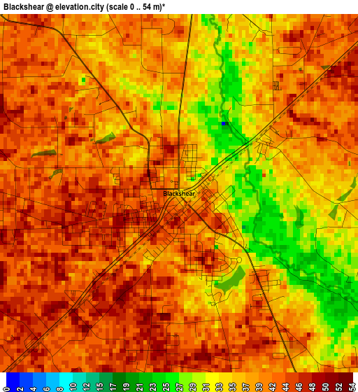
Below is the Elevation map of Blackshear, which displays elevation range with different colors. Scale of the first map is from 0 to 54 m (0 to 177 ft) with average elevation of 39.2 meters (=129 ft) [note 1]
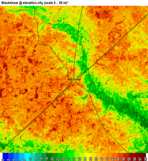
These maps also provides idea of topography and contour of this city, they are displayed at different zoom levels. More info about maps, scale and edge coordinates you can find below images.
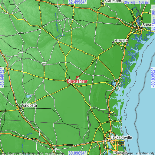
| \ | Map #1 | Map #2 | Topo.Map |
| Scale [m] | 0..54 m | 0..59 m | × |
| Scale [ft] | 0..177 ft | 0..194 ft | × |
| Average | 39.2 m = 129 ft | 39.2 m = 129 ft | × |
| Width | 8.35 km = 5.2 mi | 16.7 km = 10.4 mi | 267.2 km = 166 mi |
| Height | 8.35 km = 5.2 mi | 16.7 km = 10.4 mi | 267.2 km = 166 mi |
| ↑Max Latitude | 31.34359° | 31.381114° | 32.49984° |
| Latitude at center | 31.30605° | 31.30605° | 31.30605° |
| ↓Min Latitude | 31.268495° | 31.230926° | 30.09694° |
| ← Min Longitude | -82.286015° | -82.329961° | -83.64832° |
| Longitude center | -82.24207° | -82.24207° | -82.24207° |
| →Max Longitude | -82.198125° | -82.154179° | -80.83582° |
Nearby cities:
Cities around Blackshear sort by population:
• Waycross elevation 43 m
14.9 km,  226°
226°
• Douglas 80 m
61.9 km,  291°
291°
• Jesup 33 m
47.6 km,  45°
45°
• Folkston 29 m
57.2 km,  157°
157°
• Baxley 64 m
53.5 km,  349°
349°
• Alma 62 m
33.3 km,  321°
321°
• Nicholls 63 m
44.1 km,  302°
302°
• Homerville 56 m
56.6 km,  238°
238°
• Deenwood 50 m
16.7 km, 235°
• Pearson 65 m
58 km,  269°
269°
• Sunnyside 44 m
12.1 km, 232°
• Nahunta 24 m
27.2 km,  114°
114°
Multilingual:
 En español:
Blackshear elevación 33 m.
 En France:
Blackshear élévation 33 m.
 Auf Deutsch:
Blackshear höhe über dem Meeresspiegel ist 33 m.

Sources and notes:
- [note 1] Map square and city borders are not equal. Map elevation data is calculated only from area inside that square.
- [src 1] Elevation data from geonames database provided with same terms of usage.
- [src 2] The elevation map of Blackshear is generated using elevation data from NASA's 3 arcsec (90m) resolution SRTM data.
- [src 3] Base (background) map © OpenStreetMap contributors tiles are generated by Geofabrik and OpenTopoMap.
Copyright & License:
This Blackshear Elevation Map is licensed under CC BY-SA. You may reuse any part from this page, if you give a proper credit by linking to this URL:
 More info on terms of use page.