Abbeville elevation
Abbeville (Georgia, Wilcox County), United States elevation is 90 meters and Abbeville elevation in feet is 295 ft above sea level [src 1]. Abbeville is a seat of a second-order administrative division (feature code) with elevation that is 189 meters (620 ft) smaller than average city elevation in United States.
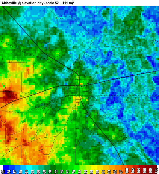
Below is the Elevation map of Abbeville, which displays elevation range with different colors. Scale of the first map is from 52 to 111 m (171 to 364 ft) with average elevation of 71.3 meters (=234 ft) [note 1]
These maps also provides idea of topography and contour of this city, they are displayed at different zoom levels. More info about maps, scale and edge coordinates you can find below images.
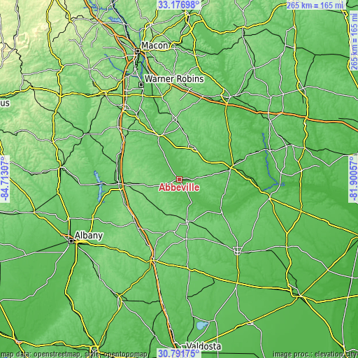
| \ | Map #1 | Topo.Map |
| Scale [m] | 52..111 m | × |
| Scale [ft] | 171..364 ft | × |
| Average | 71.3 m = 234 ft | × |
| Width | 8.29 km = 5.2 mi | 265.2 km = 164.8 mi |
| Height | 8.29 km = 5.2 mi | 265.2 km = 164.8 mi |
| ↑Max Latitude | 32.029383° | 33.17698° |
| Latitude at center | 31.99212° | 31.99212° |
| ↓Min Latitude | 31.954841° | 30.79175° |
| ← Min Longitude | -83.350765° | -84.71307° |
| Longitude center | -83.30682° | -83.30682° |
| →Max Longitude | -83.262875° | -81.90057° |
Nearby cities:
Cities around Abbeville sort by population:
• Cordele elevation 96 m
45 km,  265°
265°
• Fitzgerald 110 m
31.2 km,  170°
170°
• McRae 76 m
39.2 km,  77°
77°
• Hawkinsville 86 m
36 km,  334°
334°
• Eastman 109 m
25.9 km,  28°
28°
• Cochran 110 m
44.1 km,  354°
354°
• Ashburn 133 m
45.6 km,  225°
225°
• Vienna 100 m
47.4 km,  283°
283°
• Ocilla 109 m
44.5 km, 173°
• Helena 74 m
38.1 km, 76°
• Chester 114 m
46.9 km,  17°
17°
• Rochelle 123 m
14.8 km,  252°
252°
Multilingual:
 En español:
Abbeville elevación 90 m.
 En France:
Abbeville élévation 90 m.
 Auf Deutsch:
Abbeville höhe über dem Meeresspiegel ist 90 m.

Sources and notes:
- [note 1] Map square and city borders are not equal. Map elevation data is calculated only from area inside that square.
- [src 1] Elevation data from geonames database provided with same terms of usage.
- [src 2] The elevation map of Abbeville is generated using elevation data from NASA's 3 arcsec (90m) resolution SRTM data.
- [src 3] Base (background) map © OpenStreetMap contributors tiles are generated by Geofabrik and OpenTopoMap.
Copyright & License:
This Abbeville Elevation Map is licensed under CC BY-SA. You may reuse any part from this page, if you give a proper credit by linking to this URL:
 More info on terms of use page.