Watertown elevation
Watertown (Florida, Columbia County), United States elevation is 61 meters and Watertown elevation in feet is 200 ft above sea level [src 1]. Watertown is a populated place (feature code) with elevation that is 218 meters (715 ft) smaller than average city elevation in United States.
Below is the Elevation map of Watertown, which displays elevation range with different colors. Scale of the first map is from 32 to 66 m (105 to 217 ft) with average elevation of 54.2 meters (=178 ft) [note 1]
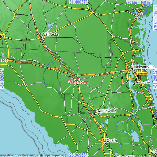
These maps also provides idea of topography and contour of this city, they are displayed at different zoom levels. More info about maps, scale and edge coordinates you can find below images.
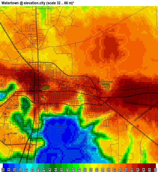
| \ | Map #1 | Topo.Map |
| Scale [m] | 32..66 m | × |
| Scale [ft] | 105..217 ft | × |
| Average | 54.2 m = 178 ft | × |
| Width | 8.45 km = 5.3 mi | 270.3 km = 168 mi |
| Height | 8.45 km = 5.3 mi | 270.3 km = 168 mi |
| ↑Max Latitude | 30.230426° | 31.40037° |
| Latitude at center | 30.19245° | 30.19245° |
| ↓Min Latitude | 30.154459° | 28.96953° |
| ← Min Longitude | -82.658515° | -84.02082° |
| Longitude center | -82.61457° | -82.61457° |
| →Max Longitude | -82.570625° | -81.20832° |
Nearby cities:
Cities around Watertown sort by population:
• Lake City elevation 64 m
2.4 km,  262°
262°
• Alachua 46 m
52.3 km,  159°
159°
• Live Oak 36 m
37.3 km,  287°
287°
• Macclenny 44 m
48.4 km,  78°
78°
• High Springs 22 m
40.7 km,  177°
177°
• Newberry 24 m
60.7 km, 179°
• Starke 47 m
55.9 km,  119°
119°
• Jasper 49 m
48.3 km,  318°
318°
• Wellborn 62 m
20.2 km,  282°
282°
• Lake Butler 46 m
32.5 km,  125°
125°
• Five Points 54 m
2.9 km,  310°
310°
• Mayo 29 m
56.1 km,  253°
253°
Multilingual:
 En español:
Watertown elevación 61 m.
 En France:
Watertown élévation 61 m.
 Auf Deutsch:
Watertown höhe über dem Meeresspiegel ist 61 m.

Sources and notes:
- [note 1] Map square and city borders are not equal. Map elevation data is calculated only from area inside that square.
- [src 1] Elevation data from geonames database provided with same terms of usage.
- [src 2] The elevation map of Watertown is generated using elevation data from NASA's 3 arcsec (90m) resolution SRTM data.
- [src 3] Base (background) map © OpenStreetMap contributors tiles are generated by Geofabrik and OpenTopoMap.
Copyright & License:
This Watertown Elevation Map is licensed under CC BY-SA. You may reuse any part from this page, if you give a proper credit by linking to this URL:
 More info on terms of use page.