Tavares elevation
Tavares (Florida, Lake County), United States elevation is 27 meters and Tavares elevation in feet is 89 ft above sea level [src 1]. Tavares is a seat of a second-order administrative division (feature code) with elevation that is 252 meters (827 ft) smaller than average city elevation in United States.
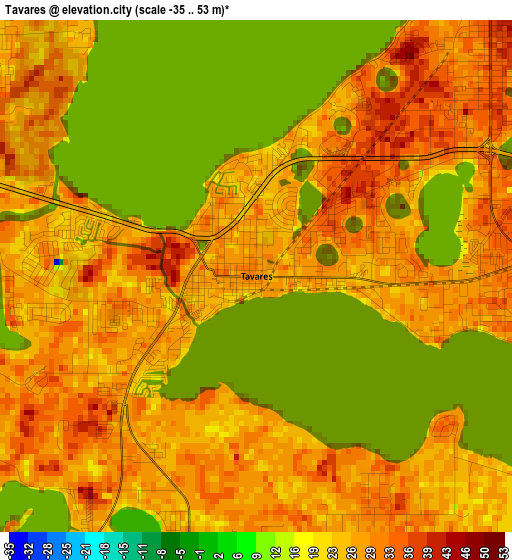
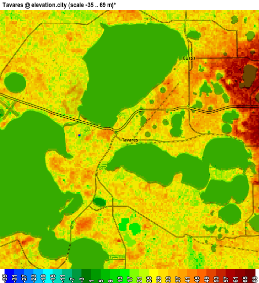
Below is the Elevation map of Tavares, which displays elevation range with different colors. Scale of the first map is from -35 to 53 m (-115 to 174 ft) with average elevation of 25.7 meters (=84 ft) [note 1]
These maps also provides idea of topography and contour of this city, they are displayed at different zoom levels. More info about maps, scale and edge coordinates you can find below images.
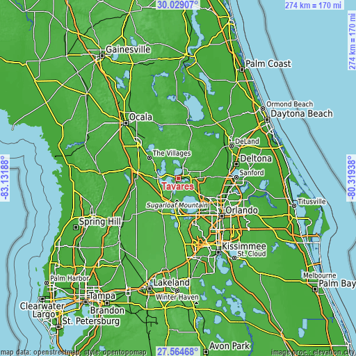
| \ | Map #1 | Map #2 | Topo.Map |
| Scale [m] | -35..53 m | -35..69 m | × |
| Scale [ft] | -115..174 ft | -115..226 ft | × |
| Average | 25.7 m = 84 ft | 26.6 m = 87 ft | × |
| Width | 8.56 km = 5.3 mi | 17.13 km = 10.6 mi | 274 km = 170.3 mi |
| Height | 8.56 km = 5.3 mi | 17.13 km = 10.6 mi | 274 km = 170.3 mi |
| ↑Max Latitude | 28.842661° | 28.881148° | 30.02907° |
| Latitude at center | 28.80416° | 28.80416° | 28.80416° |
| ↓Min Latitude | 28.765645° | 28.727115° | 27.56468° |
| ← Min Longitude | -81.769575° | -81.813521° | -83.13188° |
| Longitude center | -81.72563° | -81.72563° | -81.72563° |
| →Max Longitude | -81.681685° | -81.637739° | -80.31938° |
Nearby cities:
Cities around Tavares sort by population:
• Leesburg elevation 34 m
14.9 km,  272°
272°
• Eustis 24 m
6.7 km,  35°
35°
• Mount Dora 49 m
7.9 km,  91°
91°
• Fruitland Park 38 m
18.7 km,  289°
289°
• Umatilla 33 m
15.1 km,  22°
22°
• Tangerine 52 m
10.2 km,  115°
115°
• Zellwood 39 m
14.6 km, 123°
• Astatula 31 m
10.5 km,  183°
183°
• Silver Lake 17 m
8.2 km,  300°
300°
• Hawthorne 34 m
14.9 km,  251°
251°
• Yalaha 26 m
10.9 km,  227°
227°
• Howey-in-the-Hills 42 m
10.8 km,  205°
205°
Multilingual:
 En español:
Tavares elevación 27 m.
 En France:
Tavares élévation 27 m.


Sources and notes:
- [note 1] Map square and city borders are not equal. Map elevation data is calculated only from area inside that square.
- [src 1] Elevation data from geonames database provided with same terms of usage.
- [src 2] The elevation map of Tavares is generated using elevation data from NASA's 3 arcsec (90m) resolution SRTM data.
- [src 3] Base (background) map © OpenStreetMap contributors tiles are generated by Geofabrik and OpenTopoMap.
Copyright & License:
This Tavares Elevation Map is licensed under CC BY-SA. You may reuse any part from this page, if you give a proper credit by linking to this URL:
 More info on terms of use page.