Tangelo Park elevation
Tangelo Park (Florida, Orange County), United States elevation is 32 meters and Tangelo Park elevation in feet is 105 ft above sea level [src 1]. Tangelo Park is a populated place (feature code) with elevation that is 247 meters (810 ft) smaller than average city elevation in United States.
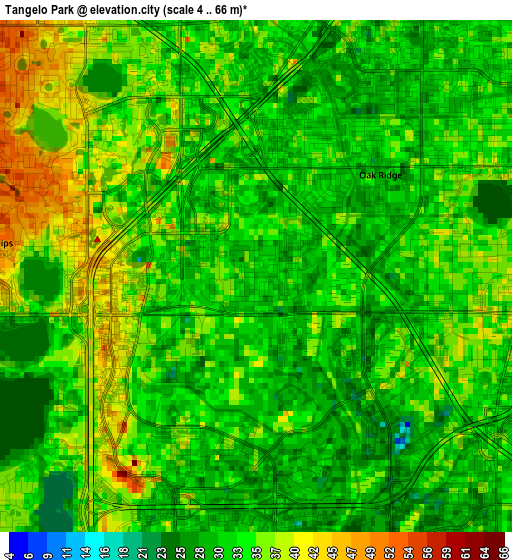
Below is the Elevation map of Tangelo Park, which displays elevation range with different colors. Scale of the first map is from 4 to 66 m (13 to 217 ft) with average elevation of 33.6 meters (=110 ft) [note 1]
These maps also provides idea of topography and contour of this city, they are displayed at different zoom levels. More info about maps, scale and edge coordinates you can find below images.
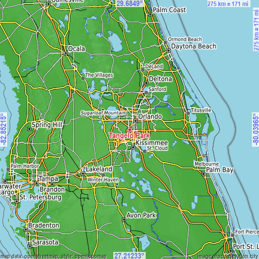
| \ | Map #1 | Topo.Map |
| Scale [m] | 4..66 m | × |
| Scale [ft] | 13..217 ft | × |
| Average | 33.6 m = 110 ft | × |
| Width | 8.59 km = 5.3 mi | 274.9 km = 170.8 mi |
| Height | 8.59 km = 5.3 mi | 274.9 km = 170.8 mi |
| ↑Max Latitude | 28.494469° | 29.6849° |
| Latitude at center | 28.45584° | 28.45584° |
| ↓Min Latitude | 28.417197° | 27.21233° |
| ← Min Longitude | -81.489845° | -82.85215° |
| Longitude center | -81.4459° | -81.4459° |
| →Max Longitude | -81.401955° | -80.03965° |
Nearby cities:
Cities around Tangelo Park sort by population:
• Oak Ridge elevation 33 m
2.7 km,  50°
50°
• Southchase 29 m
9.3 km,  138°
138°
• Doctor Phillips 40 m
4.6 km,  261°
261°
• Pine Castle 32 m
7.8 km,  76°
76°
• Williamsburg 28 m
4.6 km,  176°
176°
• Belle Isle 38 m
8.5 km,  88°
88°
• Sky Lake 33 m
5.3 km, 88°
• Orlovista 40 m
9.3 km,  351°
351°
• Bay Hill 35 m
7 km,  281°
281°
• Holden Heights 33 m
7.3 km, 51°
• Edgewood 36 m
7.9 km,  64°
64°
• Taft 30 m
8.4 km,  110°
110°
Multilingual:
 En español:
Tangelo Park elevación 32 m.
 En France:
Tangelo Park élévation 32 m.
 Auf Deutsch:
Tangelo Park höhe über dem Meeresspiegel ist 32 m.

Sources and notes:
- [note 1] Map square and city borders are not equal. Map elevation data is calculated only from area inside that square.
- [src 1] Elevation data from geonames database provided with same terms of usage.
- [src 2] The elevation map of Tangelo Park is generated using elevation data from NASA's 3 arcsec (90m) resolution SRTM data.
- [src 3] Base (background) map © OpenStreetMap contributors tiles are generated by Geofabrik and OpenTopoMap.
Copyright & License:
This Tangelo Park Elevation Map is licensed under CC BY-SA. You may reuse any part from this page, if you give a proper credit by linking to this URL:
 More info on terms of use page.