Sebring elevation
Sebring (Florida, Highlands County), United States elevation is 46 meters and Sebring elevation in feet is 151 ft above sea level [src 1]. Sebring is a seat of a second-order administrative division (feature code) with elevation that is 233 meters (764 ft) smaller than average city elevation in United States.
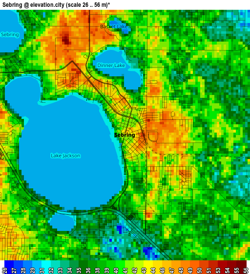
Below is the Elevation map of Sebring, which displays elevation range with different colors. Scale of the first map is from 26 to 56 m (85 to 184 ft) with average elevation of 38 meters (=125 ft) [note 1]
These maps also provides idea of topography and contour of this city, they are displayed at different zoom levels. More info about maps, scale and edge coordinates you can find below images.
| \ | Map #1 | Map #2 | Topo.Map |
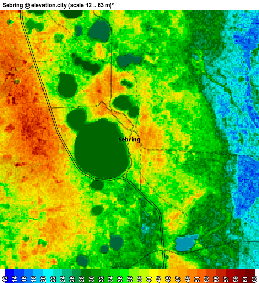
| Scale [m] | 26..56 m | 12..63 m | × |
| Scale [ft] | 85..184 ft | 39..207 ft | × |
| Average | 38 m = 125 ft | 36.1 m = 118 ft | × |
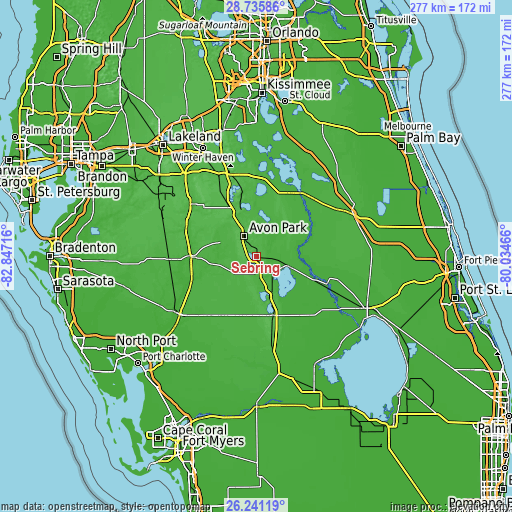
| Width | 8.67 km = 5.4 mi | 17.34 km = 10.8 mi | 277.4 km = 172.4 mi |
| Height | 8.67 km = 5.4 mi | 17.34 km = 10.8 mi | 277.4 km = 172.4 mi |
| ↑Max Latitude | 27.534565° | 27.573525° | 28.73586° |
| Latitude at center | 27.49559° | 27.49559° | 27.49559° |
| ↓Min Latitude | 27.456602° | 27.417599° | 26.24119° |
| ← Min Longitude | -81.484855° | -81.528801° | -82.84716° |
| Longitude center | -81.44091° | -81.44091° | -81.44091° |
| →Max Longitude | -81.396965° | -81.353019° | -80.03466° |
Nearby cities:
Cities around Sebring sort by population:
• Lake Wales elevation 48 m
47.3 km,  342°
342°
• Avon Park 50 m
12.9 km,  330°
330°
• Fort Meade 47 m
45.6 km,  308°
308°
• Wauchula 37 m
37 km,  278°
278°
• Alturas 55 m
49.8 km, 327°
• Placid Lakes 43 m
28.5 km,  173°
173°
• Frostproof 38 m
29.2 km, 342°
• Bowling Green 41 m
41 km,  292°
292°
• Lake Placid 19 m
19.6 km,  144°
144°
• Zolfo Springs 23 m
35 km,  269°
269°
• Crooked Lake Park 39 m
39.7 km, 339°
• Babson Park 47 m
38.3 km,  347°
347°
Multilingual:
 En español:
Sebring elevación 46 m.
 En France:
Sebring élévation 46 m.


Sources and notes:
- [note 1] Map square and city borders are not equal. Map elevation data is calculated only from area inside that square.
- [src 1] Elevation data from geonames database provided with same terms of usage.
- [src 2] The elevation map of Sebring is generated using elevation data from NASA's 3 arcsec (90m) resolution SRTM data.
- [src 3] Base (background) map © OpenStreetMap contributors tiles are generated by Geofabrik and OpenTopoMap.
Copyright & License:
This Sebring Elevation Map is licensed under CC BY-SA. You may reuse any part from this page, if you give a proper credit by linking to this URL:
 More info on terms of use page.