Lake Panasoffkee elevation
Lake Panasoffkee (Florida, Sumter County), United States elevation is 20 meters and Lake Panasoffkee elevation in feet is 66 ft above sea level [src 1]. Lake Panasoffkee is a populated place (feature code) with elevation that is 259 meters (850 ft) smaller than average city elevation in United States.
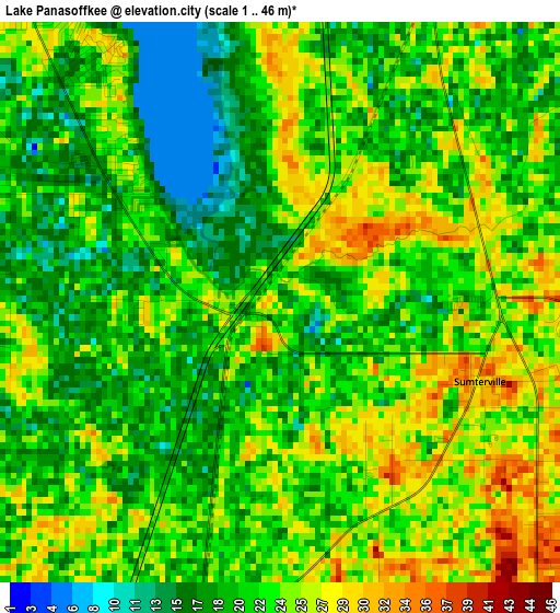
Below is the Elevation map of Lake Panasoffkee, which displays elevation range with different colors. Scale of the first map is from 1 to 46 m (3 to 151 ft) with average elevation of 22 meters (=72 ft) [note 1]
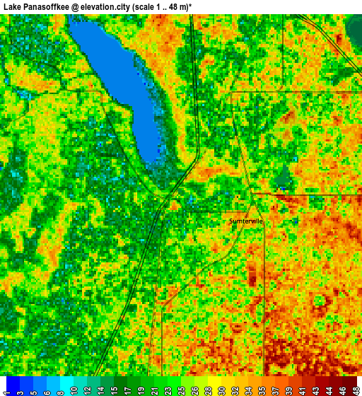
These maps also provides idea of topography and contour of this city, they are displayed at different zoom levels. More info about maps, scale and edge coordinates you can find below images.
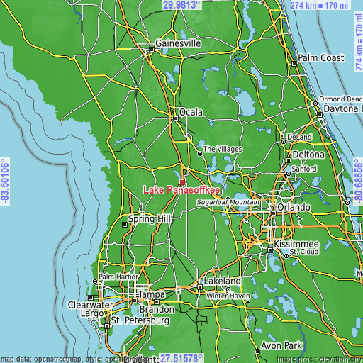
| \ | Map #1 | Map #2 | Topo.Map |
| Scale [m] | 1..46 m | 1..48 m | × |
| Scale [ft] | 3..151 ft | 3..157 ft | × |
| Average | 22 m = 72 ft | 24.7 m = 81 ft | × |
| Width | 8.57 km = 5.3 mi | 17.13 km = 10.6 mi | 274.1 km = 170.3 mi |
| Height | 8.57 km = 5.3 mi | 17.13 km = 10.6 mi | 274.1 km = 170.3 mi |
| ↑Max Latitude | 28.794339° | 28.832843° | 29.9813° |
| Latitude at center | 28.75582° | 28.75582° | 28.75582° |
| ↓Min Latitude | 28.717287° | 28.67874° | 27.51578° |
| ← Min Longitude | -82.138755° | -82.182701° | -83.50106° |
| Longitude center | -82.09481° | -82.09481° | -82.09481° |
| →Max Longitude | -82.050865° | -82.006919° | -80.68856° |
Nearby cities:
Cities around Lake Panasoffkee sort by population:
• The Villages elevation 28 m
23.8 km,  33°
33°
• Leesburg 34 m
22 km,  73°
73°
• Lady Lake 35 m
24.6 km,  42°
42°
• Inverness 21 m
24.6 km,  291°
291°
• Wildwood 23 m
13.3 km,  23°
23°
• Inverness Highlands South 25 m
24.1 km,  281°
281°
• Floral City 24 m
19.7 km,  268°
268°
• Fruitland Park 38 m
21.8 km,  57°
57°
• Bushnell 26 m
10.3 km,  189°
189°
• Hawthorne 34 m
21.8 km,  88°
88°
• Yalaha 26 m
28 km, 93°
• Center Hill 36 m
15.4 km,  139°
139°
Multilingual:
 En español:
Lake Panasoffkee elevación 20 m.
 En France:
Lake Panasoffkee élévation 20 m.
 Auf Deutsch:
Lake Panasoffkee höhe über dem Meeresspiegel ist 20 m.

Sources and notes:
- [note 1] Map square and city borders are not equal. Map elevation data is calculated only from area inside that square.
- [src 1] Elevation data from geonames database provided with same terms of usage.
- [src 2] The elevation map of Lake Panasoffkee is generated using elevation data from NASA's 3 arcsec (90m) resolution SRTM data.
- [src 3] Base (background) map © OpenStreetMap contributors tiles are generated by Geofabrik and OpenTopoMap.
Copyright & License:
This Lake Panasoffkee Elevation Map is licensed under CC BY-SA. You may reuse any part from this page, if you give a proper credit by linking to this URL:
 More info on terms of use page.