Gainesville elevation
Gainesville (Florida, Alachua County), United States elevation is 37 meters and Gainesville elevation in feet is 121 ft above sea level [src 1]. Gainesville is a seat of a second-order administrative division (feature code) with elevation that is 242 meters (794 ft) smaller than average city elevation in United States.
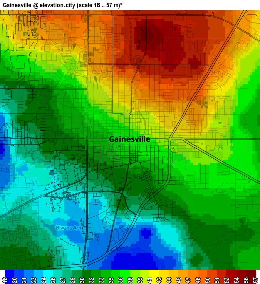
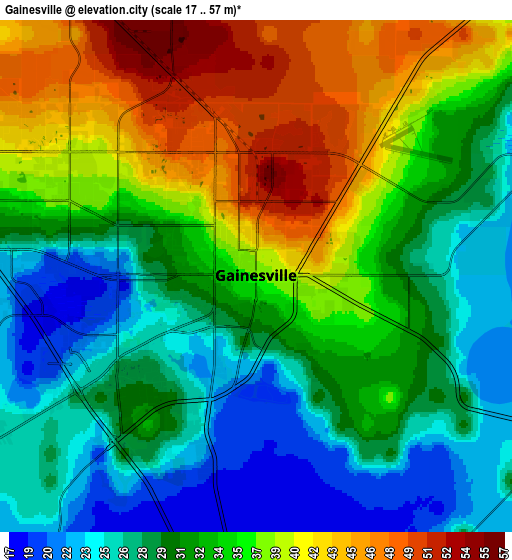
Below is the Elevation map of Gainesville, which displays elevation range with different colors. Scale of the first map is from 18 to 57 m (59 to 187 ft) with average elevation of 35.6 meters (=117 ft) [note 1]
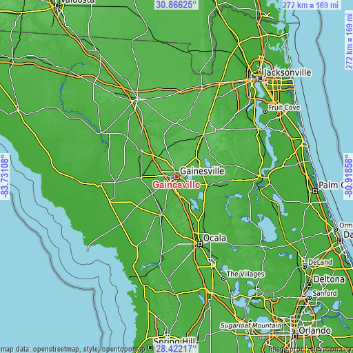
These maps also provides idea of topography and contour of this city, they are displayed at different zoom levels. More info about maps, scale and edge coordinates you can find below images.
| \ | Map #1 | Map #2 | Topo.Map |
| Scale [m] | 18..57 m | 17..57 m | × |
| Scale [ft] | 59..187 ft | 56..187 ft | × |
| Average | 35.6 m = 117 ft | 33 m = 108 ft | × |
| Width | 8.49 km = 5.3 mi | 16.99 km = 10.6 mi | 271.8 km = 168.9 mi |
| Height | 8.49 km = 5.3 mi | 16.99 km = 10.6 mi | 271.8 km = 168.9 mi |
| ↑Max Latitude | 29.689813° | 29.727982° | 30.86625° |
| Latitude at center | 29.65163° | 29.65163° | 29.65163° |
| ↓Min Latitude | 29.613432° | 29.57522° | 28.42217° |
| ← Min Longitude | -82.368775° | -82.412721° | -83.73108° |
| Longitude center | -82.32483° | -82.32483° | -82.32483° |
| →Max Longitude | -82.280885° | -82.236939° | -80.91858° |
Nearby cities:
Cities around Gainesville sort by population:
• Alachua elevation 46 m
14.7 km,  319°
319°
• High Springs 22 m
32.7 km,  306°
306°
• Citra 31 m
33.8 km,  142°
142°
• Newberry 24 m
27.2 km,  268°
268°
• Starke 47 m
38.6 km,  32°
32°
• Williston 22 m
31.7 km,  201°
201°
• East Bronson 24 m
33.4 km,  230°
230°
• Hawthorne 54 m
23.9 km,  106°
106°
• Keystone Heights 45 m
32 km,  62°
62°
• Archer 24 m
23.1 km, 234°
• Bronson 22 m
38.2 km, 233°
• Waldo 47 m
21.6 km,  44°
44°
Multilingual:
 En español:
Gainesville elevación 37 m.
 En France:
Gainesville élévation 37 m.
 Auf Deutsch:
Gainesville höhe über dem Meeresspiegel ist 37 m.

Sources and notes:
- [note 1] Map square and city borders are not equal. Map elevation data is calculated only from area inside that square.
- [src 1] Elevation data from geonames database provided with same terms of usage.
- [src 2] The elevation map of Gainesville is generated using elevation data from NASA's 3 arcsec (90m) resolution SRTM data.
- [src 3] Base (background) map © OpenStreetMap contributors tiles are generated by Geofabrik and OpenTopoMap.
Copyright & License:
This Gainesville Elevation Map is licensed under CC BY-SA. You may reuse any part from this page, if you give a proper credit by linking to this URL:
 More info on terms of use page.