Prairie Grove elevation
Prairie Grove (Arkansas, Washington County), United States elevation is 361 meters and Prairie Grove elevation in feet is 1184 ft above sea level [src 1]. Prairie Grove is a populated place (feature code) with elevation that is 82 meters (269 ft) bigger than average city elevation in United States.
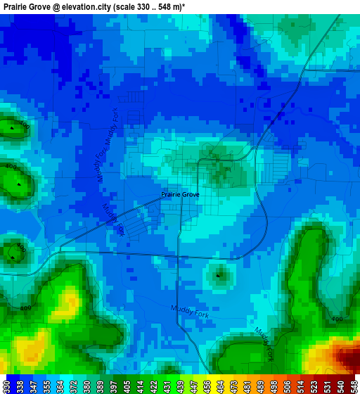
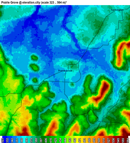
Below is the Elevation map of Prairie Grove, which displays elevation range with different colors. Scale of the first map is from 330 to 548 m (1083 to 1798 ft) with average elevation of 368.1 meters (=1208 ft) [note 1]
These maps also provides idea of topography and contour of this city, they are displayed at different zoom levels. More info about maps, scale and edge coordinates you can find below images.
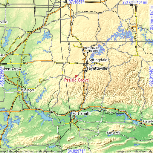
| \ | Map #1 | Map #2 | Topo.Map |
| Scale [m] | 330..548 m | 323..564 m | × |
| Scale [ft] | 1083..1798 ft | 1060..1850 ft | × |
| Average | 368.1 m = 1208 ft | 390.5 m = 1281 ft | × |
| Width | 7.91 km = 4.9 mi | 15.82 km = 9.8 mi | 253.1 km = 157.3 mi |
| Height | 7.91 km = 4.9 mi | 15.82 km = 9.8 mi | 253.1 km = 157.3 mi |
| ↑Max Latitude | 36.011465° | 36.047005° | 37.1057° |
| Latitude at center | 35.97591° | 35.97591° | 35.97591° |
| ↓Min Latitude | 35.940339° | 35.904751° | 34.82971° |
| ← Min Longitude | -94.361655° | -94.405601° | -95.72396° |
| Longitude center | -94.31771° | -94.31771° | -94.31771° |
| →Max Longitude | -94.273765° | -94.229819° | -92.91146° |
Nearby cities:
Cities around Prairie Grove sort by population:
• Fayetteville elevation 436 m
17.3 km,  56°
56°
• Springdale 406 m
28.9 km,  35°
35°
• Siloam Springs 349 m
30.9 km,  319°
319°
• Farmington 367 m
9.7 km, 40°
• Johnson 369 m
22.2 km, 38°
• Elkins 376 m
28 km,  84°
84°
• Tontitown 399 m
23.7 km,  18°
18°
• West Fork 411 m
13 km,  116°
116°
• Lincoln 451 m
10 km,  252°
252°
• Elm Springs 367 m
26.7 km, 16°
• Westville 347 m
22.6 km,  274°
274°
• Greenland 384 m
13 km, 80°
Multilingual:
 En español:
Prairie Grove elevación 361 m.
 En France:
Prairie Grove élévation 361 m.
 Auf Deutsch:
Prairie Grove höhe über dem Meeresspiegel ist 361 m.

Sources and notes:
- [note 1] Map square and city borders are not equal. Map elevation data is calculated only from area inside that square.
- [src 1] Elevation data from geonames database provided with same terms of usage.
- [src 2] The elevation map of Prairie Grove is generated using elevation data from NASA's 3 arcsec (90m) resolution SRTM data.
- [src 3] Base (background) map © OpenStreetMap contributors tiles are generated by Geofabrik and OpenTopoMap.
Copyright & License:
This Prairie Grove Elevation Map is licensed under CC BY-SA. You may reuse any part from this page, if you give a proper credit by linking to this URL:
 More info on terms of use page.