Piggott elevation
Piggott (Arkansas, Clay County), United States elevation is 89 meters and Piggott elevation in feet is 292 ft above sea level [src 1]. Piggott is a populated place (feature code) with elevation that is 190 meters (623 ft) smaller than average city elevation in United States.
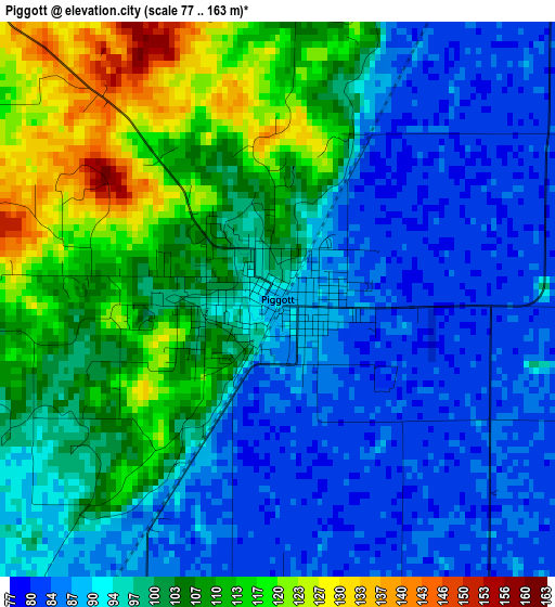
Below is the Elevation map of Piggott, which displays elevation range with different colors. Scale of the first map is from 77 to 163 m (253 to 535 ft) with average elevation of 98.3 meters (=323 ft) [note 1]
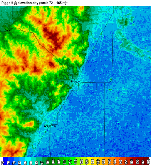
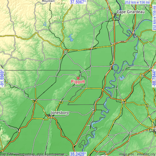
These maps also provides idea of topography and contour of this city, they are displayed at different zoom levels. More info about maps, scale and edge coordinates you can find below images.
| \ | Map #1 | Map #2 | Topo.Map |
| Scale [m] | 77..163 m | 72..165 m | × |
| Scale [ft] | 253..535 ft | 236..541 ft | × |
| Average | 98.3 m = 323 ft | 99 m = 325 ft | × |
| Width | 7.87 km = 4.9 mi | 15.74 km = 9.8 mi | 251.8 km = 156.5 mi |
| Height | 7.87 km = 4.9 mi | 15.74 km = 9.8 mi | 251.8 km = 156.5 mi |
| ↑Max Latitude | 36.418211° | 36.453566° | 37.5067° |
| Latitude at center | 36.38284° | 36.38284° | 36.38284° |
| ↓Min Latitude | 36.347453° | 36.31205° | 35.2425° |
| ← Min Longitude | -90.234595° | -90.278541° | -91.5969° |
| Longitude center | -90.19065° | -90.19065° | -90.19065° |
| →Max Longitude | -90.146705° | -90.102759° | -88.7844° |
Nearby cities:
Cities around Piggott sort by population:
• Kennett elevation 82 m
20.3 km,  143°
143°
• Malden 90 m
27.9 km,  45°
45°
• Corning 89 m
34.9 km,  274°
274°
• Portageville 84 m
44.2 km,  83°
83°
• Hayti 82 m
42.9 km,  112°
112°
• Bernie 91 m
37.5 km,  31°
31°
• Campbell 96 m
16.1 km,  40°
40°
• Rector 89 m
16.1 km,  214°
214°
• Senath 77 m
27.8 km,  174°
174°
• Clarkton 91 m
21.4 km,  69°
69°
• Marmaduke 83 m
27.8 km,  218°
218°
• Gideon 82 m
25.5 km, 72°
Multilingual:
 En español:
Piggott elevación 89 m.
 En France:
Piggott élévation 89 m.


Sources and notes:
- [note 1] Map square and city borders are not equal. Map elevation data is calculated only from area inside that square.
- [src 1] Elevation data from geonames database provided with same terms of usage.
- [src 2] The elevation map of Piggott is generated using elevation data from NASA's 3 arcsec (90m) resolution SRTM data.
- [src 3] Base (background) map © OpenStreetMap contributors tiles are generated by Geofabrik and OpenTopoMap.
Copyright & License:
This Piggott Elevation Map is licensed under CC BY-SA. You may reuse any part from this page, if you give a proper credit by linking to this URL:
 More info on terms of use page.