Earle elevation
Earle (Arkansas, Crittenden County), United States elevation is 62 meters and Earle elevation in feet is 203 ft above sea level [src 1]. Earle is a populated place (feature code) with elevation that is 217 meters (712 ft) smaller than average city elevation in United States.
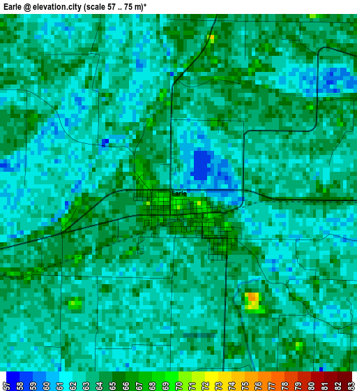
Below is the Elevation map of Earle, which displays elevation range with different colors. Scale of the first map is from 57 to 75 m (187 to 246 ft) with average elevation of 62.8 meters (=206 ft) [note 1]
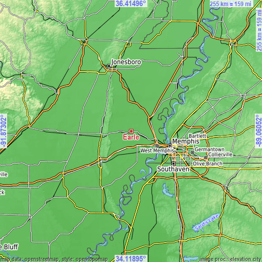
These maps also provides idea of topography and contour of this city, they are displayed at different zoom levels. More info about maps, scale and edge coordinates you can find below images.
| \ | Map #1 | Topo.Map |
| Scale [m] | 57..75 m | × |
| Scale [ft] | 187..246 ft | × |
| Average | 62.8 m = 206 ft | × |
| Width | 7.98 km = 5 mi | 255.3 km = 158.6 mi |
| Height | 7.98 km = 5 mi | 255.3 km = 158.6 mi |
| ↑Max Latitude | 35.310959° | 36.41496° |
| Latitude at center | 35.27509° | 35.27509° |
| ↓Min Latitude | 35.239206° | 34.11895° |
| ← Min Longitude | -90.510715° | -91.87302° |
| Longitude center | -90.46677° | -90.46677° |
| →Max Longitude | -90.422825° | -89.06052° |
Nearby cities:
Cities around Earle sort by population:
• Memphis elevation 84 m
40.4 km,  110°
110°
• New South Memphis 79 m
42.7 km,  119°
119°
• West Memphis 66 m
29.4 km, 119°
• Forrest City 78 m
41.8 km,  224°
224°
• Marion 69 m
25.5 km, 105°
• Wynne 82 m
29.6 km,  259°
259°
• Trumann 66 m
44.5 km,  355°
355°
• Marked Tree 68 m
29 km,  8°
8°
• Harrisburg 94 m
39.3 km,  324°
324°
• Lepanto 67 m
39.4 km,  18°
18°
• Hughes 63 m
36.2 km,  180°
180°
• Parkin 63 m
9.6 km, 262°
Multilingual:
 En español:
Earle elevación 62 m.
 En France:
Earle élévation 62 m.


Sources and notes:
- [note 1] Map square and city borders are not equal. Map elevation data is calculated only from area inside that square.
- [src 1] Elevation data from geonames database provided with same terms of usage.
- [src 2] The elevation map of Earle is generated using elevation data from NASA's 3 arcsec (90m) resolution SRTM data.
- [src 3] Base (background) map © OpenStreetMap contributors tiles are generated by Geofabrik and OpenTopoMap.
Copyright & License:
This Earle Elevation Map is licensed under CC BY-SA. You may reuse any part from this page, if you give a proper credit by linking to this URL:
 More info on terms of use page.