Dumas elevation
Dumas (Arkansas, Desha County), United States elevation is 52 meters and Dumas elevation in feet is 171 ft above sea level [src 1]. Dumas is a populated place (feature code) with elevation that is 227 meters (745 ft) smaller than average city elevation in United States.
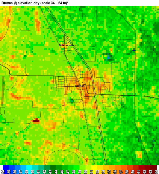
Below is the Elevation map of Dumas, which displays elevation range with different colors. Scale of the first map is from 34 to 64 m (112 to 210 ft) with average elevation of 49.4 meters (=162 ft) [note 1]
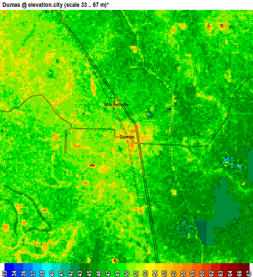
These maps also provides idea of topography and contour of this city, they are displayed at different zoom levels. More info about maps, scale and edge coordinates you can find below images.
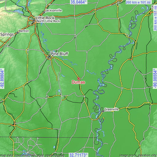
| \ | Map #1 | Map #2 | Topo.Map |
| Scale [m] | 34..64 m | 33..67 m | × |
| Scale [ft] | 112..210 ft | 108..220 ft | × |
| Average | 49.4 m = 162 ft | 48.7 m = 160 ft | × |
| Width | 8.11 km = 5 mi | 16.23 km = 10.1 mi | 259.6 km = 161.3 mi |
| Height | 8.11 km = 5 mi | 16.23 km = 10.1 mi | 259.6 km = 161.3 mi |
| ↑Max Latitude | 33.923523° | 33.95998° | 35.0464° |
| Latitude at center | 33.88705° | 33.88705° | 33.88705° |
| ↓Min Latitude | 33.850562° | 33.814057° | 32.71173° |
| ← Min Longitude | -91.535735° | -91.579681° | -92.89804° |
| Longitude center | -91.49179° | -91.49179° | -91.49179° |
| →Max Longitude | -91.447845° | -91.403899° | -90.08554° |
Nearby cities:
Cities around Dumas sort by population:
• Pine Bluff elevation 68 m
60.5 km,  308°
308°
• Monticello 96 m
39.9 km,  223°
223°
• Warren 70 m
61.1 km,  240°
240°
• McGehee 48 m
29.9 km,  163°
163°
• De Witt 60 m
47.3 km,  17°
17°
• Pea Ridge 49 m
14.8 km,  75°
75°
• Dermott 46 m
40.5 km,  172°
172°
• Lake Village 29 m
65.1 km, 162°
• Star City 88 m
33 km,  280°
280°
• Rosedale 48 m
43 km,  94°
94°
• Rison 87 m
64.9 km, 277°
• Arkansas City 44 m
40.6 km,  139°
139°
Multilingual:
 En español:
Dumas elevación 52 m.
 En France:
Dumas élévation 52 m.


Sources and notes:
- [note 1] Map square and city borders are not equal. Map elevation data is calculated only from area inside that square.
- [src 1] Elevation data from geonames database provided with same terms of usage.
- [src 2] The elevation map of Dumas is generated using elevation data from NASA's 3 arcsec (90m) resolution SRTM data.
- [src 3] Base (background) map © OpenStreetMap contributors tiles are generated by Geofabrik and OpenTopoMap.
Copyright & License:
This Dumas Elevation Map is licensed under CC BY-SA. You may reuse any part from this page, if you give a proper credit by linking to this URL:
 More info on terms of use page.