Des Arc elevation
Des Arc (Arkansas, Prairie County), United States elevation is 61 meters and Des Arc elevation in feet is 200 ft above sea level [src 1]. Des Arc is a populated place (feature code) with elevation that is 218 meters (715 ft) smaller than average city elevation in United States.
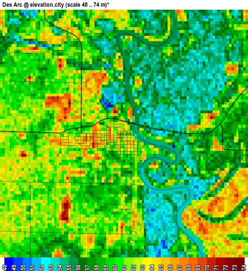
Below is the Elevation map of Des Arc, which displays elevation range with different colors. Scale of the first map is from 48 to 74 m (157 to 243 ft) with average elevation of 58.8 meters (=193 ft) [note 1]
These maps also provides idea of topography and contour of this city, they are displayed at different zoom levels. More info about maps, scale and edge coordinates you can find below images.
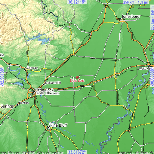
| \ | Map #1 | Topo.Map |
| Scale [m] | 48..74 m | × |
| Scale [ft] | 157..243 ft | × |
| Average | 58.8 m = 193 ft | × |
| Width | 8.01 km = 5 mi | 256.2 km = 159.2 mi |
| Height | 8.01 km = 5 mi | 256.2 km = 159.2 mi |
| ↑Max Latitude | 35.01304° | 36.12115° |
| Latitude at center | 34.97704° | 34.97704° |
| ↓Min Latitude | 34.941024° | 33.81672° |
| ← Min Longitude | -91.539075° | -92.90138° |
| Longitude center | -91.49513° | -91.49513° |
| →Max Longitude | -91.451185° | -90.08888° |
Nearby cities:
Cities around Des Arc sort by population:
• Searcy elevation 82 m
37.5 km,  324°
324°
• Beebe 75 m
36.5 km,  286°
286°
• Ward 76 m
41.9 km,  278°
278°
• Bald Knob 70 m
37.6 km,  349°
349°
• Brinkley 61 m
29.1 km,  109°
109°
• Carlisle 73 m
31.5 km,  226°
226°
• Augusta 71 m
35.9 km,  19°
19°
• Judsonia 67 m
35.1 km,  338°
338°
• Kensett 68 m
32.4 km,  331°
331°
• McCrory 63 m
41 km,  40°
40°
• Clarendon 55 m
35.6 km,  152°
152°
• Hazen 71 m
23.2 km,  199°
199°
Multilingual:
 En español:
Des Arc elevación 61 m.
 En France:
Des Arc élévation 61 m.


Sources and notes:
- [note 1] Map square and city borders are not equal. Map elevation data is calculated only from area inside that square.
- [src 1] Elevation data from geonames database provided with same terms of usage.
- [src 2] The elevation map of Des Arc is generated using elevation data from NASA's 3 arcsec (90m) resolution SRTM data.
- [src 3] Base (background) map © OpenStreetMap contributors tiles are generated by Geofabrik and OpenTopoMap.
Copyright & License:
This Des Arc Elevation Map is licensed under CC BY-SA. You may reuse any part from this page, if you give a proper credit by linking to this URL:
 More info on terms of use page.