Crossett elevation
Crossett (Arkansas, Ashley County), United States elevation is 58 meters and Crossett elevation in feet is 190 ft above sea level [src 1]. Crossett is a populated place (feature code) with elevation that is 221 meters (725 ft) smaller than average city elevation in United States.
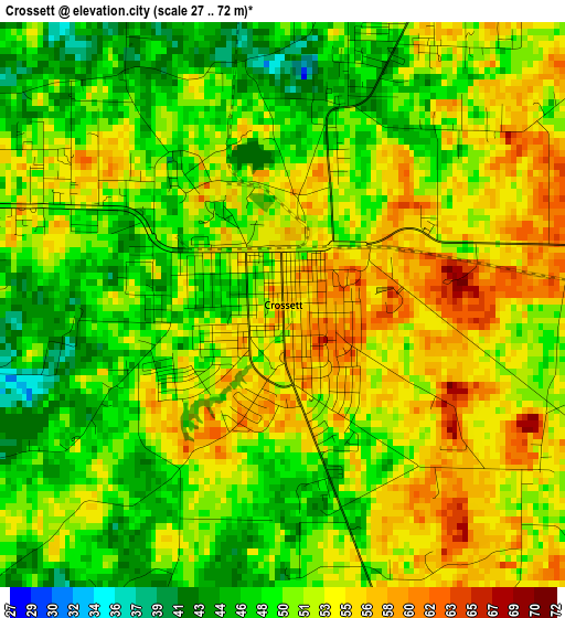
Below is the Elevation map of Crossett, which displays elevation range with different colors. Scale of the first map is from 27 to 72 m (89 to 236 ft) with average elevation of 51.3 meters (=168 ft) [note 1]
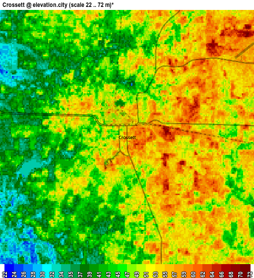
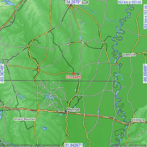
These maps also provides idea of topography and contour of this city, they are displayed at different zoom levels. More info about maps, scale and edge coordinates you can find below images.
| \ | Map #1 | Map #2 | Topo.Map |
| Scale [m] | 27..72 m | 22..72 m | × |
| Scale [ft] | 89..236 ft | 72..236 ft | × |
| Average | 51.3 m = 168 ft | 47.9 m = 157 ft | × |
| Width | 8.18 km = 5.1 mi | 16.37 km = 10.2 mi | 261.9 km = 162.7 mi |
| Height | 8.18 km = 5.1 mi | 16.37 km = 10.2 mi | 261.9 km = 162.7 mi |
| ↑Max Latitude | 33.164974° | 33.201753° | 34.2979° |
| Latitude at center | 33.12818° | 33.12818° | 33.12818° |
| ↓Min Latitude | 33.09137° | 33.054545° | 31.94267° |
| ← Min Longitude | -92.005185° | -92.049131° | -93.36749° |
| Longitude center | -91.96124° | -91.96124° | -91.96124° |
| →Max Longitude | -91.917295° | -91.873349° | -90.55499° |
Nearby cities:
Cities around Crossett sort by population:
• Bastrop elevation 37 m
39.2 km,  173°
173°
• Monticello 96 m
57.9 km,  15°
15°
• Warren 70 m
54.7 km,  349°
349°
• Swartz 31 m
62.2 km,  182°
182°
• Farmerville 56 m
57.2 km,  226°
226°
• North Crossett 49 m
4.6 km, 23°
• Hamburg 54 m
18.9 km,  53°
53°
• Sterlington 25 m
49.4 km,  193°
193°
• Eudora 42 m
65.1 km,  91°
91°
• Oak Grove 40 m
61.1 km,  119°
119°
• Hampton 65 m
65.6 km,  313°
313°
• West Crossett 51 m
3.4 km,  294°
294°
Multilingual:
 En español:
Crossett elevación 58 m.
 En France:
Crossett élévation 58 m.


Sources and notes:
- [note 1] Map square and city borders are not equal. Map elevation data is calculated only from area inside that square.
- [src 1] Elevation data from geonames database provided with same terms of usage.
- [src 2] The elevation map of Crossett is generated using elevation data from NASA's 3 arcsec (90m) resolution SRTM data.
- [src 3] Base (background) map © OpenStreetMap contributors tiles are generated by Geofabrik and OpenTopoMap.
Copyright & License:
This Crossett Elevation Map is licensed under CC BY-SA. You may reuse any part from this page, if you give a proper credit by linking to this URL:
 More info on terms of use page.