Cherokee Village elevation
Cherokee Village (Arkansas, Sharp County), United States elevation is 200 meters and Cherokee Village elevation in feet is 656 ft above sea level [src 1]. Cherokee Village is a populated place (feature code) with elevation that is 79 meters (259 ft) smaller than average city elevation in United States.
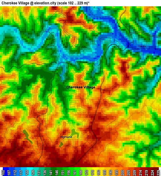
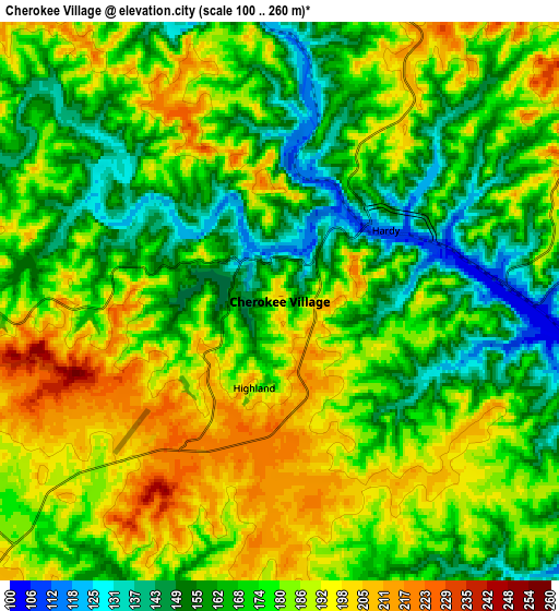
Below is the Elevation map of Cherokee Village, which displays elevation range with different colors. Scale of the first map is from 102 to 229 m (335 to 751 ft) with average elevation of 170.3 meters (=559 ft) [note 1]
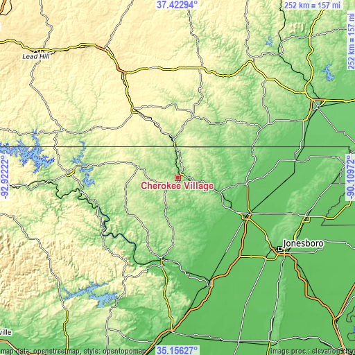
These maps also provides idea of topography and contour of this city, they are displayed at different zoom levels. More info about maps, scale and edge coordinates you can find below images.
| \ | Map #1 | Map #2 | Topo.Map |
| Scale [m] | 102..229 m | 100..260 m | × |
| Scale [ft] | 335..751 ft | 328..853 ft | × |
| Average | 170.3 m = 559 ft | 176.3 m = 578 ft | × |
| Width | 7.88 km = 4.9 mi | 15.75 km = 9.8 mi | 252 km = 156.6 mi |
| Height | 7.88 km = 4.9 mi | 15.75 km = 9.8 mi | 252 km = 156.6 mi |
| ↑Max Latitude | 36.33325° | 36.368643° | 37.42294° |
| Latitude at center | 36.29784° | 36.29784° | 36.29784° |
| ↓Min Latitude | 36.262414° | 36.226972° | 35.15627° |
| ← Min Longitude | -91.559915° | -91.603861° | -92.92222° |
| Longitude center | -91.51597° | -91.51597° | -91.51597° |
| →Max Longitude | -91.472025° | -91.428079° | -90.10972° |
Nearby cities:
Cities around Cherokee Village sort by population:
• West Plains elevation 307 m
56.5 km,  327°
327°
• Pocahontas 95 m
49 km,  94°
94°
• Walnut Ridge 82 m
56.4 km,  116°
116°
• Hoxie 79 m
55.8 km, 119°
• Thayer 167 m
25.3 km,  355°
355°
• Horseshoe Bend 268 m
23.5 km,  251°
251°
• Cave City 204 m
39.7 km,  184°
184°
• Melbourne 188 m
44.1 km,  233°
233°
• Salem 202 m
28.7 km,  286°
286°
• Ash Flat 203 m
11.7 km, 225°
• Highland 189 m
2.5 km,  196°
196°
• Alton 242 m
45.3 km,  13°
13°
Multilingual:
 En español:
Cherokee Village elevación 200 m.
 En France:
Cherokee Village élévation 200 m.
 Auf Deutsch:
Cherokee Village höhe über dem Meeresspiegel ist 200 m.

Sources and notes:
- [note 1] Map square and city borders are not equal. Map elevation data is calculated only from area inside that square.
- [src 1] Elevation data from geonames database provided with same terms of usage.
- [src 2] The elevation map of Cherokee Village is generated using elevation data from NASA's 3 arcsec (90m) resolution SRTM data.
- [src 3] Base (background) map © OpenStreetMap contributors tiles are generated by Geofabrik and OpenTopoMap.
Copyright & License:
This Cherokee Village Elevation Map is licensed under CC BY-SA. You may reuse any part from this page, if you give a proper credit by linking to this URL:
 More info on terms of use page.