Tarrant elevation
Tarrant (Alabama, Jefferson County), United States elevation is 170 meters and Tarrant elevation in feet is 558 ft above sea level [src 1]. Tarrant is a populated place (feature code) with elevation that is 109 meters (358 ft) smaller than average city elevation in United States.
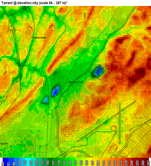
Below is the Elevation map of Tarrant, which displays elevation range with different colors. Scale of the first map is from 84 to 267 m (276 to 876 ft) with average elevation of 193.8 meters (=636 ft) [note 1]
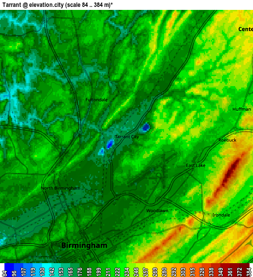
These maps also provides idea of topography and contour of this city, they are displayed at different zoom levels. More info about maps, scale and edge coordinates you can find below images.

| \ | Map #1 | Map #2 | Topo.Map |
| Scale [m] | 84..267 m | 84..384 m | × |
| Scale [ft] | 276..876 ft | 276..1260 ft | × |
| Average | 193.8 m = 636 ft | 207.3 m = 680 ft | × |
| Width | 8.14 km = 5.1 mi | 16.28 km = 10.1 mi | 260.5 km = 161.9 mi |
| Height | 8.14 km = 5.1 mi | 16.28 km = 10.1 mi | 260.5 km = 161.9 mi |
| ↑Max Latitude | 33.620042° | 33.656629° | 34.74696° |
| Latitude at center | 33.58344° | 33.58344° | 33.58344° |
| ↓Min Latitude | 33.546822° | 33.510189° | 32.40401° |
| ← Min Longitude | -86.816715° | -86.860661° | -88.17902° |
| Longitude center | -86.77277° | -86.77277° | -86.77277° |
| →Max Longitude | -86.728825° | -86.684879° | -85.36652° |
Nearby cities:
Cities around Tarrant sort by population:
• Birmingham elevation 187 m
7.5 km,  201°
201°
• Homewood 212 m
12.7 km,  191°
191°
• Mountain Brook 237 m
9.4 km,  168°
168°
• Center Point 256 m
10.8 km,  50°
50°
• Gardendale 207 m
9.3 km,  336°
336°
• Irondale 228 m
7.9 km,  129°
129°
• Forestdale 200 m
11.5 km,  262°
262°
• Fultondale 196 m
3.1 km,  320°
320°
• Grayson Valley 289 m
14.3 km,  59°
59°
• Cahaba Heights 201 m
13.8 km,  164°
164°
• Mount Olive 188 m
12.4 km, 321°
• Chalkville 268 m
13.9 km, 56°
Multilingual:
 En español:
Tarrant elevación 170 m.
 En France:
Tarrant élévation 170 m.


Sources and notes:
- [note 1] Map square and city borders are not equal. Map elevation data is calculated only from area inside that square.
- [src 1] Elevation data from geonames database provided with same terms of usage.
- [src 2] The elevation map of Tarrant is generated using elevation data from NASA's 3 arcsec (90m) resolution SRTM data.
- [src 3] Base (background) map © OpenStreetMap contributors tiles are generated by Geofabrik and OpenTopoMap.
Copyright & License:
This Tarrant Elevation Map is licensed under CC BY-SA. You may reuse any part from this page, if you give a proper credit by linking to this URL:
 More info on terms of use page.